One can test the hypothesis that 'differential erosion' is a significant factor in shaping the details of landscape in the areas discussed above by comparing land surface elevation to the character of the underlying bedrock. This may be done using the following procedure. 1. 2. Examine the topographic profile X-Y shown in Figure 7, above. The location of this profile is indicated in Figures 3 and 5. Create a geologic cross section by placing the edge of a blank piece of paper along line X-Y in Figure 5. Carefully mark the locations of the end of the line (points X and Y) on the edge of the paper. Now draw strips of black on the edge of the paper to indicate the locations of all bedrock that is relatively resistant to erosion (all patterns on the map except the New Jersey "Redbeds" and the Inwood Formation). Next, take the marked edge of the paper and place it along the topographic profile X-Y in Figure 7. Wherever there is a resistant rock present, make a vertical black stripe from the top to the bottom of the profile. Do the ridges and valleys on the topographic profile coincide, respectively, with the black and white sections along the geologic cross section? Yes No Is the hypothesis of differential erosion confirmed or negated? (Circle One) Confirmed
One can test the hypothesis that 'differential erosion' is a significant factor in shaping the details of landscape in the areas discussed above by comparing land surface elevation to the character of the underlying bedrock. This may be done using the following procedure. 1. 2. Examine the topographic profile X-Y shown in Figure 7, above. The location of this profile is indicated in Figures 3 and 5. Create a geologic cross section by placing the edge of a blank piece of paper along line X-Y in Figure 5. Carefully mark the locations of the end of the line (points X and Y) on the edge of the paper. Now draw strips of black on the edge of the paper to indicate the locations of all bedrock that is relatively resistant to erosion (all patterns on the map except the New Jersey "Redbeds" and the Inwood Formation). Next, take the marked edge of the paper and place it along the topographic profile X-Y in Figure 7. Wherever there is a resistant rock present, make a vertical black stripe from the top to the bottom of the profile. Do the ridges and valleys on the topographic profile coincide, respectively, with the black and white sections along the geologic cross section? Yes No Is the hypothesis of differential erosion confirmed or negated? (Circle One) Confirmed

Applications and Investigations in Earth Science (9th Edition)
9th Edition
ISBN:9780134746241
Author:Edward J. Tarbuck, Frederick K. Lutgens, Dennis G. Tasa
Publisher:Edward J. Tarbuck, Frederick K. Lutgens, Dennis G. Tasa
Chapter1: The Study Of Minerals
Section: Chapter Questions
Problem 1LR

Related questions
Question
Please type your answers on the image if possible or type them on your computer. I only need the answer. So please make it clear what the answer is by writing on the image.
Transcribed Image Text:One can test the hypothesis that 'differential erosion' is a significant factor in shaping the details of landscape in the
areas discussed above by comparing land surface elevation to the character of the underlying bedrock. This may
be
done using the following procedure.
1.
2.
Examine the topographic profile X-Y shown in Figure 7, above. The location of this profile is indicated in
Figures 3 and 5.
Create a geologic cross section by placing the edge of a blank piece of paper along line X-Y in Figure 5.
Carefully mark the locations of the end of the line (points X and Y) on the edge of the paper. Now draw
strips of black on the edge of the paper to indicate the locations of all bedrock that is relatively resistant to
erosion (all patterns on the map except the New Jersey "Redbeds" and the Inwood Formation). Next, take
the marked edge of the paper and place it along the topographic profile X-Y in Figure 7. Wherever there is
a resistant rock present, make a vertical black stripe from the top to the bottom of the profile.
J
Do the ridges and valleys on the topographic profile coincide, respectively, with the black and white sections
along the geologic cross section?
Yes
No
Is the hypothesis of differential erosion confirmed or negated?
BEDROCK
III diabase
E sandstone & shale
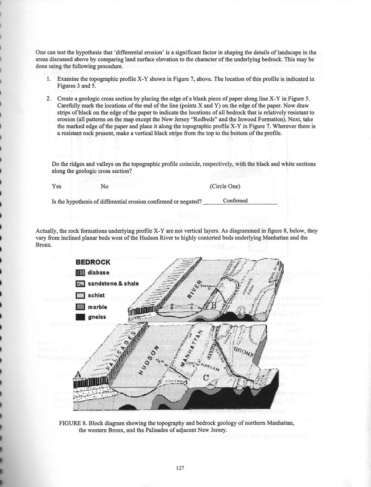
Actually, the rock formations underlying profile X-Y are not vertical layers. As diagrammed in figure 8, below, they
vary from inclined planar beds west of the Hudson River to highly contorted beds underlying Manhattan and the
Bronx.
schist
ENT
marble
gneiss
ISADES
HUDSON
ANTON
(Circle One)
MANHATTAN
127
B
Confirmed
ZUARLEN
C
VO
[***
FIGURE 8. Block diagram showing the topography and bedrock geology of northern Manhattan,
the western Bronx, and the Palisades of adjacent New Jersey.
Transcribed Image Text:The Palisades
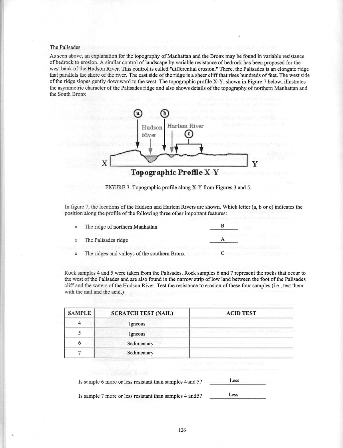
As seen above, an explanation for the topography of Manhattan and the Bronx may be found in variable resistance
of bedrock to erosion. A similar control of landscape by variable resistance of bedrock has been proposed for the
west bank of the Hudson River. This control is called "differential erosion." There, the Palisades is an elongate ridge
that parallels the shore of the river. The east side of the ridge is a sheer cliff that rises hundreds of feet. The west side
of the ridge slopes gently downward to the west. The topographic profile X-Y, shown in Figure 7 below, illustrates
the asymmetric character of the Palisades ridge and also shows details of the topography of northern Manhattan and
the South Bronx
X
X
X
X
a
SAMPLE
4
5
6
7
b
Hudson Harlem River
River
In figure 7, the locations of the Hudson and Harlem Rivers are shown. Which letter (a, b or c) indicates the
position along the profile of the following three other important features:
The ridge of northern Manhattan
The Palisades ridge
The ridges and valleys of the southern Bronx
Topographic Profile X-Y
FIGURE 7. Topographic profile along X-Y from Figures 3 and 5.
SCRATCH TEST (NAIL)
Igneous
Igneous
Sedimentary
Sedimentary
Is sample 6 more or less resistant than samples 4 and 5?
Is sample 7 more or less resistant than samples 4 and 5?
B
Rock samples 4 and 5 were taken from the Palisades. Rock samples 6 and 7 represent the rocks that occur to
the west of the Palisades and are also found in the narrow strip of low land between the foot of the Palisades
cliff and the waters of the Hudson River. Test the resistance to erosion of these four samples (i.e., test them
with the nail and the acid.)
126
65
A
Co
Y
ACID TEST
Less
Less
Expert Solution
This question has been solved!
Explore an expertly crafted, step-by-step solution for a thorough understanding of key concepts.

This is a popular solution!

Trending now
This is a popular solution!

Step by step
Solved in 2 steps with 1 images

Recommended textbooks for you
Applications and Investigations in Earth Science …
Earth Science
ISBN:
9780134746241
Author:
Edward J. Tarbuck, Frederick K. Lutgens, Dennis G. Tasa
Publisher:
PEARSON

Exercises for Weather & Climate (9th Edition)
Earth Science
ISBN:
9780134041360
Author:
Greg Carbone
Publisher:
PEARSON

Environmental Science
Earth Science
ISBN:
9781260153125
Author:
William P Cunningham Prof., Mary Ann Cunningham Professor
Publisher:
McGraw-Hill Education
Applications and Investigations in Earth Science …
Earth Science
ISBN:
9780134746241
Author:
Edward J. Tarbuck, Frederick K. Lutgens, Dennis G. Tasa
Publisher:
PEARSON
Exercises for Weather & Climate (9th Edition)
Earth Science
ISBN:
9780134041360
Author:
Greg Carbone
Publisher:
PEARSON
Environmental Science
Earth Science
ISBN:
9781260153125
Author:
William P Cunningham Prof., Mary Ann Cunningham Professor
Publisher:
McGraw-Hill Education

Earth Science (15th Edition)
Earth Science
ISBN:
9780134543536
Author:
Edward J. Tarbuck, Frederick K. Lutgens, Dennis G. Tasa
Publisher:
PEARSON

Environmental Science (MindTap Course List)
Earth Science
ISBN:
9781337569613
Author:
G. Tyler Miller, Scott Spoolman
Publisher:
Cengage Learning

Physical Geology
Earth Science
ISBN:
9781259916823
Author:
Plummer, Charles C., CARLSON, Diane H., Hammersley, Lisa
Publisher:
Mcgraw-hill Education,