What is a Control survey?
Control surveys or survey controls are used to establish reference points as a basis for various construction activities. Vertical and horizontal control points are to be established in a control survey to increase accuracy. After establishing the control points, all other types of surveys such as topographic, right-of-way, aerial mapping, construction layout, boundary surveys, and utility mapping can be worked upon so that control networks can be formed. The place from which the observations are made is called a survey station.
Geodetic reductions refer to the control surveys conducted, covering the areas which take into account the curvature and the geoid-spheroidal shape of the earth at sea level to establish a basic network of reference points, covering the first and second-order survey control. This type of survey increases the accuracy of the obtained values.
Control Datum
Control datum is a set of stable reference points (permanent objects like monuments) present on the surface of the earth. These points have a utility in finding the horizontal and vertical positions by correlating with these datums. There is a network of pre-established control monuments and benchmarks to act as a basis for vertical and horizontal datums. Latitudes and longitudes or northing and easting are defined usually by horizontal datums. Elevations and depths are defined with the help of vertical datums.
Geodetic control surveys are used to find the vertical and horizontal positions of the monuments present in the survey control networks. These control surveys increase the accuracy of the obtained values.
Control Surveys for horizontal positioning
Traversing
Traversing is a method of establishing control networks, generally finds utility in the field of surveying and geodesy. In this method, survey stations are placed along a path, in the direction in which the survey is to proceed. The point which is to be surveyed uses a previously surveyed point as a reference or base point. Open traverse (is a type traverse in which the surveyed points do not form a closed-loop and remain as an opened one) and closed traversing (is a type of traverse in which the surveyed points form a closed-loop) are the two types of closed traversing. Compass traversing, chain traversing, theodolite traversing, and plane table traversing are the four different methods for traversing.
Triangulation
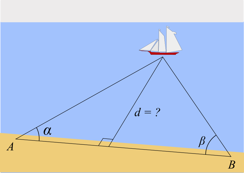
Triangulation is a surveying technique that is used to measure the angles in a triangle formed with the help of three control points. The unknown lengths of the sides of the triangle are measured using trigonometry if one side of the triangle is known. The shape of the triangle plays a vital role in this method, a triangle with a base angle of 45 degrees is suitable for this method. The Baseline is the only measured distance while the other sides of the triangles are calculated with the help of known angles and baseline.
Areas with undulating surfaces such as hills are surveyed using triangulation to establish survey stations with proper intervisibility. The steps involved in triangulation are reconnaissance, station preparation, baseline measurement, and measurement of angles.
There are certain conditions to be fulfilled geometrically to conduct triangulation,
- The sum of interior angles should be (2n-4) x 90o so that the accuracy of triangulation values can be increased, where n = number of sides of the polygon
- If all the angles are measured at a station, their sum should be 360o.
Trilateration
Trilateration is a method in which the sides of a triangle are measured using Electronic Distance Measurement Instruments (EDMIs) to increase accuracy and with this information, the angles are computed. This method is also used in GPS surveys.
GPS
GPS stands for Global Positioning System and is a radio navigation system. GPS uses accurate time, satellite signals, and refined calculations to generate distances to triangulate positions anywhere on earth. It uses earth-orbiting satellites to collect the data. The GPS provides accurate, continuous, worldwide, three-dimensional position and velocity information to users with the appropriate receiving information. The GPS is comprised of three segments, satellite constellation (space segment), ground control/monitoring network (operational control segment), and the user receiving equipment (user equipment segment). It allows accurate determination of a location and it is known for its accuracy.
Photogrammetry
Photogrammetric surveying or photogrammetry is a type of surveying in which maps are generated from photographs of a particular place of interest. There are two types of Photogrammetry survey, aerial photogrammetry (photographs are taken with help of moving airplanes) and terrestrial (photographs are taken with a camera handheld or on a tripod).
Control surveys for vertical positioning
Geodetic Leveling
In geodetic surveys carried out for mapping, geodetic positions are referred to as ellipsoid, and the elevations of the positions are referred to as geoids. For satellite geodesy, the geoidal heights must be considered to establish the correct height above the geoid. According to National Geodetic Survey, geodetic leveling is used to establish vertical control points. From these points, the height of other points of interest is measured using other supplementary methods. The mean sea-level surface used as a vertical datum is established by averaging the hourly water heights for a specified period at specified tide gauges.
There are three different types of leveling under geodetic leveling:
Differential leveling
It is accurate than the other two methods. The measuring instrument is locked in position from where the survey is to be taken, the readings are taken with the help of calibrated staff in the upright position. The difference in the elevation of the points can be obtained from the difference between readings.
Trigonometric leveling
In this leveling, theodolites are used to measure the vertical angles from a known distance. Vertical measurements can be made and at the same time, horizontal angles are measured for triangulation.
Barometric leveling
In this leveling, the height difference is obtained by measuring the atmospheric differences at various elevations. Air pressure is measured by a mercurial barometer or a boiling point thermometer.
Context and Applications
Control survey is a significant topic in the field of geodesy and construction. The topic has an important role in the following fields of engineering.
- Bachelors of Technology in Civil Engineering
- Masters of Technology in Civil Engineering
- Bachelors of Technology in Surveying Engineering
- Masters of Technology in Surveying Engineering
Practice Problems
1. What is the use of mapping in surveying?
- To establish and locate the boundary of surface and subsurface features accurately
- To establish survey control points
- To conduct spatial analysis
- None of these
Answer: Option a
Explanation: Mapping is done to locate all the man-made and natural resources on a map and establish the boundary.
2. Surveying framework is erected by measuring the angles and the lengths of the sides of a chain of triangles connecting the points fixed by global positioning.
- True
- False
Answer: True
Explanation: Surveying is done to determine the position of objects by measuring distances and angles.
3. What is the function of the National Geodetic Survey?
- To locate spatial distribution of objects
- To mark the boundary of surface and subsurface structures
- National Geodetic Survey (NGS) provides the framework for all positioning activities in the Nation.
- All of the above
Answer: Option d
Explanation: Its core function is to maintain the accuracy of the National Spatial Reference System (NSRS), a consistent coordinate system that defines latitude, longitude, height, scale, gravity, and orientation throughout the United States.
4. Which of the following is true about geodetic surveying?
- It considers the curvature of the earth while surveying.
- To accurately plot vertical control for surveying and mapping operations
- It depends on the accuracy of satellite data.
- All of the above
Answer: Option d
Explanation: The method of accurately positioning the points on the earth's surface and the dimensions of larger areas such that the curvature of the earth is taken into consideration.
5. What is spatial data in surveying?
- It consists of all geographic and topological data accurately.
- Accuracy of coordinate points of a land boundary
- Both a and b
- None of these
Answer: Option a
Explanation: Spatial data is data that has a direct or indirect reference to a specific location or geographical area.
Want more help with your civil engineering homework?
*Response times may vary by subject and question complexity. Median response time is 34 minutes for paid subscribers and may be longer for promotional offers.
Search. Solve. Succeed!
Study smarter access to millions of step-by step textbook solutions, our Q&A library, and AI powered Math Solver. Plus, you get 30 questions to ask an expert each month.
Control Survey and Geodetic reductions Homework Questions from Fellow Students
Browse our recently answered Control Survey and Geodetic reductions homework questions.
Search. Solve. Succeed!
Study smarter access to millions of step-by step textbook solutions, our Q&A library, and AI powered Math Solver. Plus, you get 30 questions to ask an expert each month.