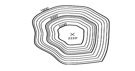
1800 2000 2200 2239


Q: 20. The X and Y coordinates of five stations of travese are given in the accompanying tabulation a…
A:
Q: ... 20. The X and Y coordinates of five stations of closed a travese are given in the accompanying…
A:
Q: 180 2000 2200 2239
A: The diagram represents the contour lines with having different RLs. In the given diagram, the value…
Q: 3) You have a plot of land that measures 1850.53' x 2353.92'. How many square chains is this? 4)…
A: 3) The given area is shown below: 1850.53'×2353.92'
Q: Compute the lengths and azimuths of the sides of a closed-polygon traverse whose corners have the…
A: Given:- A (8000.000, 5000.000); B (2650.000, 4702.906); C (1752.028, 2015.453); D (1912.303,…
Q: What is the meaning of distance in surveying .
A: The distance is a numerical measurement between two points or objects, which shows how far the…
Q: Considering the topographic map below, a) What is the contour interval? b) What is the lowest…
A:
Q: The areas within contour lines at the site of a reservoir and along the face of the proposed dam are…
A:
Q: What kind of information is provided by U.S. Geological Survey Topographic Quadrangle Maps?
A: The distinctive aspect of a topographic map with the use of contour lines of altitude to indicate…
Q: The distance scaled on a 1:15,000 map between two adjacent contours is 50mm. Determine the slope of…
A: Given that, the distance scaled on a 1:15,000 map between two adjacent contours = 50mm contour…
Q: On a map the distance between the end points of a line AB (assumed to be of uniform slope) is 10.5…
A:
Q: Sample plates about Open Compass Traverse from a topographics map
A: Answer:- Open compass traverse:- A compass traverse is a method of filling in detail on a…
Q: The distance scaled on a 1:10000 map between two adjacent contours is 25mm. Determine the slope of…
A:
Q: An area of 150 km × 110 km is to be surveyed using photogrammetry. From the data given below,…
A:
Q: Compute the east coordinates of point Q in the below figure if you know the east coordinates of…
A: Given:- East coordinates of point R=14462.087m Length of Line RQ =L RQ=595.848m To find:- east…
Q: The scale of a map is 1 cm 50 m. The distance scaled on the map between two adjacent contours is 18…
A:
Q: A topographic map has a contour interval of 1 foot and a scale of 1 inch = 20 feet. If two adjacent…
A: Given data, Contour interval = 1 feet Scale = 1 inch = 20 feet Adjacent contours are 0.25 inch apart
Q: 1) What kind of topographic landform is represented in the illustration? 2) What is the contour…
A: Contour:- A contour is defined as the imaginary lines passing through the points of equal elevation…
Q: The (X,Y) coordinates (in feet) for a closed-polygon traverse ABCDEFA follow. A (1000.00, 1000.00),…
A: The given data is as follows: Coordinates of point A=1000.00,1000.00 ftCoordinates of point…
Q: Compute the east coordinates of point Q in the below figure if you know the east coordinates of…
A: Given:- The east coordinates of the point R = 13291.831 m The length of the line RQ = 501.181 m…
Q: Understanding check. v What kind of topographic landform is represented in the following…
A: Given data Contour lines Some are light while others are dark. This is surveying part.
Q: 2. Draw a topographic profile along a horizontal line passing through the centre of the diagram and…
A: Contour lines: A contour line for relevant features is a path that unites points of equal value and…
Q: A six-sided closed-loop traverse has the following station coordinates: 738.562 666.737 559.319…
A: Consider the figure.
Q: Given the data of a closed traverse below, convert it into figure reflecting their corresponding…
A:
Q: The error of scale on the map is 0.02 mm. The map has a scale of 1:250,000. Find the error of…
A:
Q: a. Why is it necessary for a map to have a geographic reference presented as grids?” b. In…
A: Note: Hi! Thank you for the question As per the honour code, We’ll answer the first question since…
Q: Solve for the area of the given traverse using Double Parallel Distance Method. Given lengths in…
A:
Q: The (X,Y) coordinates (in feet) for a closed-polygon traverse ABCDEFA follow. A (1000.00, 1000.00),…
A: Method of Coordinates: Method of coordinates is used in determining the area of the closed traverse.…
Q: The interior angles of a triangular traverse were repeatedly measured, with the results shown below.…
A:
Q: An area of land is bounded by straight sides in the shape of a five-sided clockwise polygon ABCDEA.…
A:
Q: Given the data of a closed traverse below, convert it into figure reflecting their corresponding…
A: The azimuth is measured clockwise from the true north or true south of a reference meridian, which…
Q: The coordinates of traverse stations of a closed traverse ABCDE are given below Station X (m) A 0 B…
A:
Q: Situation 2: Given the closed traverse running anti-clockwise tabulated below, determine the missing…
A: Given X=6, Y=8
Q: Given the closed traverse shown below, determine the missing data. LINE Length (m) Azimuth from…
A: To determine the missing lengths of lines DE and EA. Given, LINE Length (m) Azimuth from North…
Q: On a 1/4000 scale map, the area of the lake is 8740 mm2. How many acres is the area of the lake…
A: A scale is defined as the ratio that dimension on the plan bears corresponding to the distance on…
Q: The following are the observed values of angles of a triangle in a triangulation survey: A = 87°35'…
A:
Q: The following are the lengths and consecutive coordinates of Traverse ABCDA. Find the correction and…
A:
Q: A topographic surveying map using a scale 1cm: 40 m, and with a contour interval of 1.0 m. The…
A: .
Q: Which of the following scales is used for the same area in a map, the detail of the map will be the…
A: There are two types of scales used on a map. * Large scale - it shows small area with greater…
Q: a) A polygon traverse has the following coordinates shown below. Calculate the area within the…
A: The area of a closed non-crossing plane polygon can be computed from the coordinates of the polygon…
Q: in traversing, what do you call the shortest distance from the midpoint of the traverse line to a…
A: The shortest distance from the midpoint of the traverse line to a reference meridian is called the…
Q: Explain how a structural dome might also be a topographic basin
A: Brief concept introduction- Structural dome- Any huge or oval structure generated by the…
Q: 1800 2000 2200 2239
A: The following points were observed from above given contour, 1. contour values are increasing from…
Q: Given the following stations with their respective offset distances, determine the area of the land…
A:
Q: What kind of topographic landform is represented in the following illustration? • What are the bold…
A: Here in the given diagram, it represents a hill or valley profile of topographic landform. Cause the…
Q: and has vertical sides is: 4 19 m Q.7 What is the ground area in meter square if the scale of a map…
A:
Q: A pentagonal traverse was surveyed for planning purposes. Accidentally, some data were deleted by…
A:
Q: 11. The (X,Y) coordinates (in feet) for a closed-polygon traverse ABCDEFA follow. A (1000.00,…
A:
Q: Q2/ The coordinates oftraverse stations of a closed traverse ABCDE are given in StationX( Tm B + 170…
A:
What kind of topographic landform is represented in the following illustration?


Trending now
This is a popular solution!

Step by step
Solved in 2 steps with 1 images
