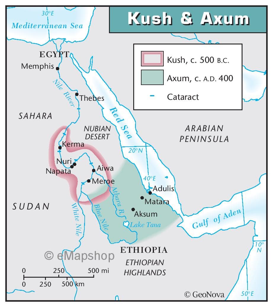
Briefly summarize the Kush & Axum map: - Geographic context: Briefly describe the geographical area or region depicted in the map. - Key features: Highlight the main elements displayed on the map. This could include physical features (mountains, rivers, coastlines), man-made structures (roads, buildings), or thematic data (population distribution, land use). - Notable patterns or trends: If there are any noteworthy patterns, trends, or significant points illustrated on the map, summarize them concisely.
Briefly summarize the Kush & Axum map: - Geographic context: Briefly describe the geographical area or region depicted in the map. - Key features: Highlight the main elements displayed on the map. This could include physical features (mountains, rivers, coastlines), man-made structures (roads, buildings), or thematic data (population distribution, land use). - Notable patterns or trends: If there are any noteworthy patterns, trends, or significant points illustrated on the map, summarize them concisely.

Related questions
Question
Briefly summarize the Kush & Axum map:
- Geographic context: Briefly describe the geographical area or region depicted in the map.
- Key features: Highlight the main elements displayed on the map. This could include physical features (mountains, rivers, coastlines), man-made structures (roads, buildings), or thematic data (population distribution, land use).
- Notable patterns or trends: If there are any noteworthy patterns, trends, or significant points illustrated on the map, summarize them concisely.
Transcribed Image Text:30°E
Mediterranean Sea
EGYPT
Memphis
SAHARA
Nile River
SUDAN
Nuri
Napata
Kerma
Thebes
White Nile
250
NUBIAN
DESERT
250 500 km
Red Sea
Aiwa
Meroe
Blue Nile
ⒸeMapshop
Atbara R.
500 mi
Kush & Axum
20°N
L
40°E
Kush, c. 500 B.C.
Axum, C. A.D. 400
Cataract
Adulis
Matara
Aksum
Lake Tana
ETHIOPIA
ETHIOPIAN
HIGHLANDS
ARABIAN
PENINSULA
Gulf of Aden
Ⓒ GeoNova
50°E
10°
N
Expert Solution
This question has been solved!
Explore an expertly crafted, step-by-step solution for a thorough understanding of key concepts.

This is a popular solution!

Trending now
This is a popular solution!

Step by step
Solved in 5 steps
