Figure below represent contour lines for ground surface and wells located on it 50 w2 W1 fill table below Water table Depth to H20 Surface Well No Elevation Table Elevation + 60 12 + 48 1 : 50 10 + 40 + 40 11 • 29 2. 3.
Figure below represent contour lines for ground surface and wells located on it 50 w2 W1 fill table below Water table Depth to H20 Surface Well No Elevation Table Elevation + 60 12 + 48 1 : 50 10 + 40 + 40 11 • 29 2. 3.

Architectural Drafting and Design (MindTap Course List)
7th Edition
ISBN:9781285165738
Author:Alan Jefferis, David A. Madsen, David P. Madsen
Publisher:Alan Jefferis, David A. Madsen, David P. Madsen
Chapter15: Site Plan Layout
Section: Chapter Questions
Problem 15.12Q

Related questions
Question
100%
Fill in the blanks according to the map,Thank you.
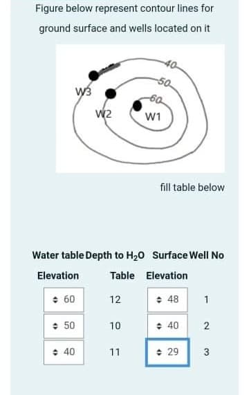
Transcribed Image Text:Figure below represent contour lines for
ground surface and wells located on it
50
W2
W1
fill table below
Water table Depth to H20 Surface Well No
Elevation
Table Elevation
+ 60
12
+ 48
1
: 50
+ 40
10
: 40
11
+ 29
3
2.
Expert Solution
This question has been solved!
Explore an expertly crafted, step-by-step solution for a thorough understanding of key concepts.

Step by step
Solved in 2 steps

Knowledge Booster


Learn more about
Need a deep-dive on the concept behind this application? Look no further. Learn more about this topic, civil-engineering and related others by exploring similar questions and additional content below.Recommended textbooks for you
Architectural Drafting and Design (MindTap Course…
Civil Engineering
ISBN:
9781285165738
Author:
Alan Jefferis, David A. Madsen, David P. Madsen
Publisher:
Cengage Learning
Architectural Drafting and Design (MindTap Course…
Civil Engineering
ISBN:
9781285165738
Author:
Alan Jefferis, David A. Madsen, David P. Madsen
Publisher:
Cengage Learning