GIS is often described as a set of computer tools to help manage, analyse and map spatial data. Unlike traditional fields of study-whereby the definition typically begins with the study of - GIS is deeply rooted as an applied skill. In this course, concepts of each lesson and tutorial build on one another and it is important to be able to demonstrate that you can identify and apply specific techniques related to each lesson. The purpose of this demonstration of skill is to be able to navigate Open Data and/or ArcGIS Online, add data to your map, and to symbolize your spatial data. This task will help you familiarize yourself with ArcGIS Pro. Task#1 In ArcGIS Pro download or add at least three datasets/layers (i.e. shapefile or feature class); at least one layer should disaster-or emergency-related. The layers you select should have some relation and not be random (e.g. tornadoes, geology, and dwellings). In the map view, create a 'map' using these layers/datasets. They should each have reasonable symbology. Be sure to save your project. Your deliverable must include: 1. Screenshot of your map (in map view) including the contents pane. 2. A sentence or two on how techniques used in this task would be useful in PS/EM. 3. You must provide proper citations of your datasets.
GIS is often described as a set of computer tools to help manage, analyse and map spatial data. Unlike traditional fields of study-whereby the definition typically begins with the study of - GIS is deeply rooted as an applied skill. In this course, concepts of each lesson and tutorial build on one another and it is important to be able to demonstrate that you can identify and apply specific techniques related to each lesson. The purpose of this demonstration of skill is to be able to navigate Open Data and/or ArcGIS Online, add data to your map, and to symbolize your spatial data. This task will help you familiarize yourself with ArcGIS Pro. Task#1 In ArcGIS Pro download or add at least three datasets/layers (i.e. shapefile or feature class); at least one layer should disaster-or emergency-related. The layers you select should have some relation and not be random (e.g. tornadoes, geology, and dwellings). In the map view, create a 'map' using these layers/datasets. They should each have reasonable symbology. Be sure to save your project. Your deliverable must include: 1. Screenshot of your map (in map view) including the contents pane. 2. A sentence or two on how techniques used in this task would be useful in PS/EM. 3. You must provide proper citations of your datasets.
Principles of Information Systems (MindTap Course List)
12th Edition
ISBN:9781285867168
Author:Ralph Stair, George Reynolds
Publisher:Ralph Stair, George Reynolds
Chapter11: Knowledge Management And Specialized Information Systems
Section: Chapter Questions
Problem 17SAT

Related questions

Question
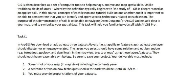
Transcribed Image Text:GIS is often described as a set of computer tools to help manage, analyse and map spatial data. Unlike
traditional fields of study-whereby the definition typically begins with 'the study of - GIS is deeply rooted as
an applied skill. In this course, concepts of each lesson and tutorial build on one another and it is important to
be able to demonstrate that you can identify and apply specific techniques related to each lesson. The
purpose of this demonstration of skill is to be able to navigate Open Data and/or ArcGIS Online, add data to
your map, and to symbolize your spatial data. This task will help you familiarize yourself with ArcGIS Pro.
Task#1
In ArcGIS Pro download or add at least three datasets/layers (i.e. shapefile or feature class); at least one layer
should disaster- or emergency-related. The layers you select should have some relation and not be random
(e.g. tornadoes, geology, and dwellings). In the map view, create a 'map' using these layers/datasets. They
should each have reasonable symbology. Be sure to save your project. Your deliverable must include:
1. Screenshot of your map (in map view) including the contents pane.
2. A sentence or two on how techniques used in this task would be useful in PS/EM.
3. You must provide proper citations of your datasets.
Expert Solution
This question has been solved!
Explore an expertly crafted, step-by-step solution for a thorough understanding of key concepts.

Step by step
Solved in 2 steps

Knowledge Booster


Learn more about
Need a deep-dive on the concept behind this application? Look no further. Learn more about this topic, computer-science and related others by exploring similar questions and additional content below.Recommended textbooks for you
Principles of Information Systems (MindTap Course…
Computer Science
ISBN:
9781285867168
Author:
Ralph Stair, George Reynolds
Publisher:
Cengage Learning
Principles of Information Systems (MindTap Course…
Computer Science
ISBN:
9781305971776
Author:
Ralph Stair, George Reynolds
Publisher:
Cengage Learning
Principles of Information Systems (MindTap Course…
Computer Science
ISBN:
9781285867168
Author:
Ralph Stair, George Reynolds
Publisher:
Cengage Learning
Principles of Information Systems (MindTap Course…
Computer Science
ISBN:
9781305971776
Author:
Ralph Stair, George Reynolds
Publisher:
Cengage Learning