In a contaminated site, three monitoring wells (into the unconfined aquifer) have been developed. The east well (surface elevation: 254 m) measures a water level 30 m below the surface. The west well (surface elevation: 279 m) measures a water level 24 m below the surface. The south well (surface elevation: 266 m) measures a water level 41 m below the surface. Please plot the direction of the groundwater flow, and calculate the contaminant's velocity if the aquifer's hydraulic conductivity is 6 x 10³ m/s and the porosity is 0.4. M Unted States CA San Bemardno Co. - Twentynine Palme West 5 km East X-- 3kml 3 km South
In a contaminated site, three monitoring wells (into the unconfined aquifer) have been developed. The east well (surface elevation: 254 m) measures a water level 30 m below the surface. The west well (surface elevation: 279 m) measures a water level 24 m below the surface. The south well (surface elevation: 266 m) measures a water level 41 m below the surface. Please plot the direction of the groundwater flow, and calculate the contaminant's velocity if the aquifer's hydraulic conductivity is 6 x 10³ m/s and the porosity is 0.4. M Unted States CA San Bemardno Co. - Twentynine Palme West 5 km East X-- 3kml 3 km South

Fundamentals of Geotechnical Engineering (MindTap Course List)
5th Edition
ISBN:9781305635180
Author:Braja M. Das, Nagaratnam Sivakugan
Publisher:Braja M. Das, Nagaratnam Sivakugan
Chapter7: Seepage
Section: Chapter Questions
Problem 7.6P

Related questions

Question
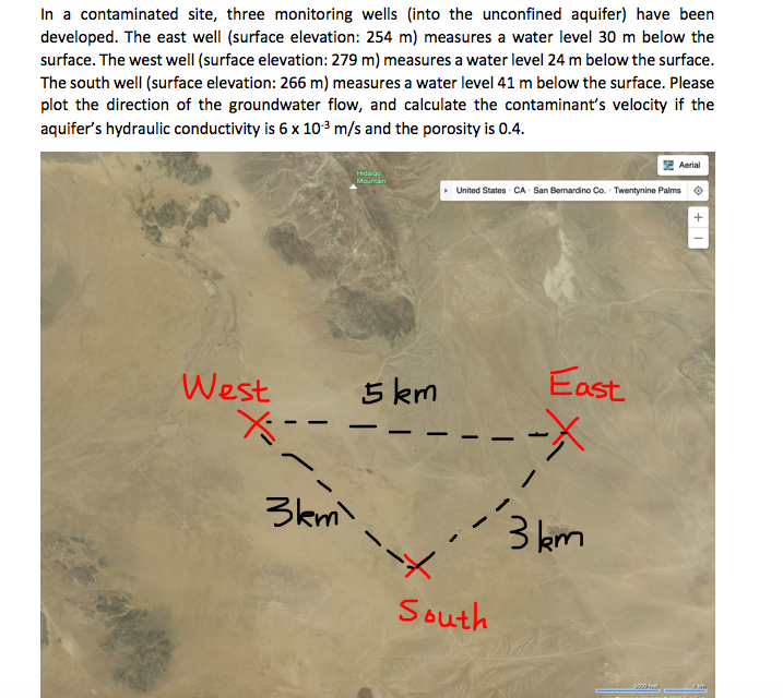
Transcribed Image Text:In a contaminated site, three monitoring wells (into the unconfined aquifer) have been
developed. The east well (surface elevation: 254 m) measures a water level 30 m below the
surface. The west well (surface elevation: 279 m) measures a water level 24 m below the surface.
The south well (surface elevation: 266 m) measures a water level 41 m below the surface. Please
plot the direction of the groundwater flow, and calculate the contaminant's velocity if the
aquifer's hydraulic conductivity is 6 x 10³ m/s and the porosity is 0.4.
SE Aerial
Hidaigo
Mournan
United States - CA San Bemardino Co. - Twentynine Palms o
West
5 km
East
-
3km)
3 km
South
+
Expert Solution
This question has been solved!
Explore an expertly crafted, step-by-step solution for a thorough understanding of key concepts.

Step by step
Solved in 3 steps with 1 images

Knowledge Booster


Learn more about
Need a deep-dive on the concept behind this application? Look no further. Learn more about this topic, civil-engineering and related others by exploring similar questions and additional content below.Recommended textbooks for you
Fundamentals of Geotechnical Engineering (MindTap…
Civil Engineering
ISBN:
9781305635180
Author:
Braja M. Das, Nagaratnam Sivakugan
Publisher:
Cengage Learning

Principles of Geotechnical Engineering (MindTap C…
Civil Engineering
ISBN:
9781305970939
Author:
Braja M. Das, Khaled Sobhan
Publisher:
Cengage Learning
Fundamentals of Geotechnical Engineering (MindTap…
Civil Engineering
ISBN:
9781305635180
Author:
Braja M. Das, Nagaratnam Sivakugan
Publisher:
Cengage Learning
Principles of Geotechnical Engineering (MindTap C…
Civil Engineering
ISBN:
9781305970939
Author:
Braja M. Das, Khaled Sobhan
Publisher:
Cengage Learning