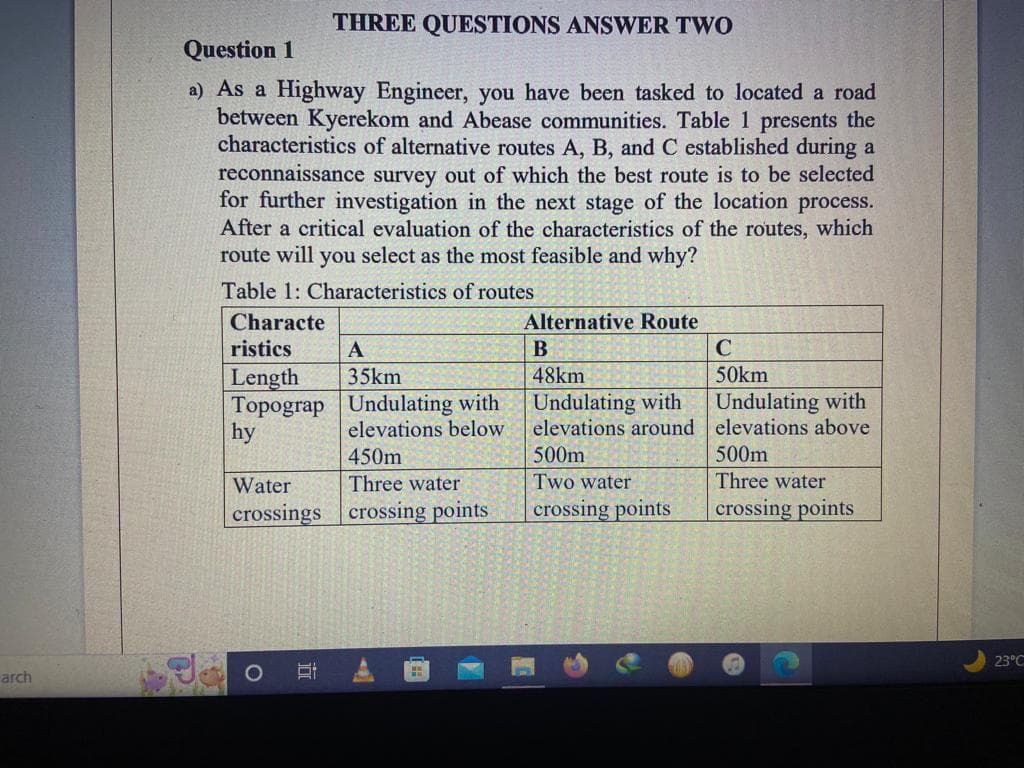
Question 1 a) As a Highway Engineer, you have been tasked to located a road between Kyerekom and Abease communities. Table 1 presents the characteristics of alternative routes A, B, and C established during a reconnaissance survey out of which the best route is to be selected for further investigation in the next stage of the location process. After a critical evaluation of the characteristics of the routes, which route will you select as the most feasible and why? Table 1: Characteristics of routes Characte ristics Length Topograp hy THREE QUESTIONS ANSWER TWO Water crossings A 35km Undulating with elevations below 450m Three water crossing points Alternative Route B 48km Undulating with elevations around 500m Two water crossing points C 50km Undulating with elevations above 500m Three water crossing points
Question 1 a) As a Highway Engineer, you have been tasked to located a road between Kyerekom and Abease communities. Table 1 presents the characteristics of alternative routes A, B, and C established during a reconnaissance survey out of which the best route is to be selected for further investigation in the next stage of the location process. After a critical evaluation of the characteristics of the routes, which route will you select as the most feasible and why? Table 1: Characteristics of routes Characte ristics Length Topograp hy THREE QUESTIONS ANSWER TWO Water crossings A 35km Undulating with elevations below 450m Three water crossing points Alternative Route B 48km Undulating with elevations around 500m Two water crossing points C 50km Undulating with elevations above 500m Three water crossing points
Traffic and Highway Engineering
5th Edition
ISBN:9781305156241
Author:Garber, Nicholas J.
Publisher:Garber, Nicholas J.
Chapter14: Highway Surveys And Location
Section: Chapter Questions
Problem 1P
Related questions
Question

Transcribed Image Text:arch
THREE QUESTIONS ANSWER TWO
Question 1
a) As a Highway Engineer, you have been tasked to located a road
between Kyerekom and Abease communities. Table 1 presents the
characteristics of alternative routes A, B, and C established during a
reconnaissance survey out of which the best route is to be selected
for further investigation in the next stage of the location process.
After a critical evaluation of the characteristics of the routes, which
route will you select as the most feasible and why?
Table 1: Characteristics of routes
Characte
ristics
Length
Topograp
hy
A
35km
Di
Undulating with
elevations below.
450m
Water
Three water
crossings crossing points
T
H
Alternative Route
B
48km
Undulating with
elevations around
500m
Two water
crossing points
C
50km
Undulating with
elevations above
500m
Three water
crossing points
23°C
Expert Solution
This question has been solved!
Explore an expertly crafted, step-by-step solution for a thorough understanding of key concepts.
Step by step
Solved in 2 steps

Knowledge Booster
Learn more about
Need a deep-dive on the concept behind this application? Look no further. Learn more about this topic, civil-engineering and related others by exploring similar questions and additional content below.Recommended textbooks for you

Traffic and Highway Engineering
Civil Engineering
ISBN:
9781305156241
Author:
Garber, Nicholas J.
Publisher:
Cengage Learning

Traffic and Highway Engineering
Civil Engineering
ISBN:
9781305156241
Author:
Garber, Nicholas J.
Publisher:
Cengage Learning