The National Park Service has conducted a cactus Distance, x (miles east) 10 20 30 census in Arizona. In order to collect data, the service divided the desert into a grid whose lines are 10 miles apart in each direction. The entries in the table to the right represent thousands of cacti per square mile at grid points in Saguaro East National Park, where the visitor center is located at (0,0). 8.5 8.2 7.9 8.1 Distance, y 10 9.5 10.6 10.5 10.1 (miles south) 20 9.3 10.5 10.4 9.5 30 8.3 8.6 9.3 9.1 (a) Let f(x, y) be the number of cacti (in thousands) per square mile x miles east and y miles south of the c30 -30 visitor center. Explain what I| $(x,y) dy dr represents in the context of this problem. (b) Give the best estimate you can based on the data of the number of cacti in the 30 by 30 test area.
The National Park Service has conducted a cactus Distance, x (miles east) 10 20 30 census in Arizona. In order to collect data, the service divided the desert into a grid whose lines are 10 miles apart in each direction. The entries in the table to the right represent thousands of cacti per square mile at grid points in Saguaro East National Park, where the visitor center is located at (0,0). 8.5 8.2 7.9 8.1 Distance, y 10 9.5 10.6 10.5 10.1 (miles south) 20 9.3 10.5 10.4 9.5 30 8.3 8.6 9.3 9.1 (a) Let f(x, y) be the number of cacti (in thousands) per square mile x miles east and y miles south of the c30 -30 visitor center. Explain what I| $(x,y) dy dr represents in the context of this problem. (b) Give the best estimate you can based on the data of the number of cacti in the 30 by 30 test area.

Algebra: Structure And Method, Book 1
(REV)00th Edition
ISBN:9780395977224
Author:Richard G. Brown, Mary P. Dolciani, Robert H. Sorgenfrey, William L. Cole
Publisher:Richard G. Brown, Mary P. Dolciani, Robert H. Sorgenfrey, William L. Cole
Chapter2: Working With Real Numbers
Section2.3: Rules For Addition
Problem 7P

Related questions
Question
How to solve this question
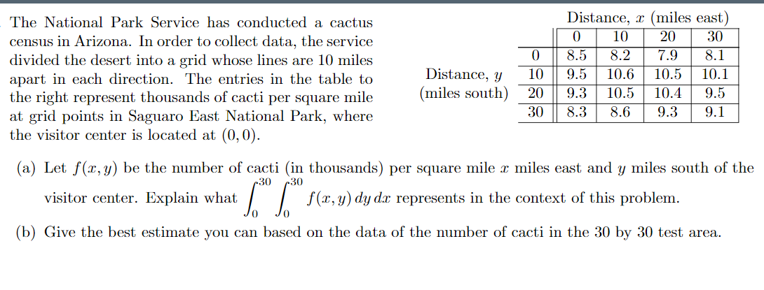
Transcribed Image Text:The National Park Service has conducted a cactus
Distance, x (miles east)
10
20
30
census in Arizona. In order to collect data, the service
divided the desert into a grid whose lines are 10 miles
apart in each direction. The entries in the table to
the right represent thousands of cacti per square mile
at grid points in Saguaro East National Park, where
the visitor center is located at (0,0).
8.5
8.2
7.9
8.1
Distance, y
10
9.5
10.6
10.5
10.1
(miles south)
20
9.3
10.5
10.4
9.5
30
8.3
8.6
9.3
9.1
(a) Let f(x, y) be the number of cacti (in thousands) per square mile x miles east and y miles south of the
c30
-30
visitor center. Explain what
I| $(x,y) dy dr represents
in the context of this problem.
(b) Give the best estimate you can based on the data of the number of cacti in the 30 by 30 test area.
Expert Solution
This question has been solved!
Explore an expertly crafted, step-by-step solution for a thorough understanding of key concepts.

This is a popular solution!

Trending now
This is a popular solution!

Step by step
Solved in 2 steps with 2 images

Recommended textbooks for you
Algebra: Structure And Method, Book 1
Algebra
ISBN:
9780395977224
Author:
Richard G. Brown, Mary P. Dolciani, Robert H. Sorgenfrey, William L. Cole
Publisher:
McDougal Littell

Elementary Geometry for College Students
Geometry
ISBN:
9781285195698
Author:
Daniel C. Alexander, Geralyn M. Koeberlein
Publisher:
Cengage Learning

Elementary Geometry For College Students, 7e
Geometry
ISBN:
9781337614085
Author:
Alexander, Daniel C.; Koeberlein, Geralyn M.
Publisher:
Cengage,
Algebra: Structure And Method, Book 1
Algebra
ISBN:
9780395977224
Author:
Richard G. Brown, Mary P. Dolciani, Robert H. Sorgenfrey, William L. Cole
Publisher:
McDougal Littell
Elementary Geometry for College Students
Geometry
ISBN:
9781285195698
Author:
Daniel C. Alexander, Geralyn M. Koeberlein
Publisher:
Cengage Learning
Elementary Geometry For College Students, 7e
Geometry
ISBN:
9781337614085
Author:
Alexander, Daniel C.; Koeberlein, Geralyn M.
Publisher:
Cengage,