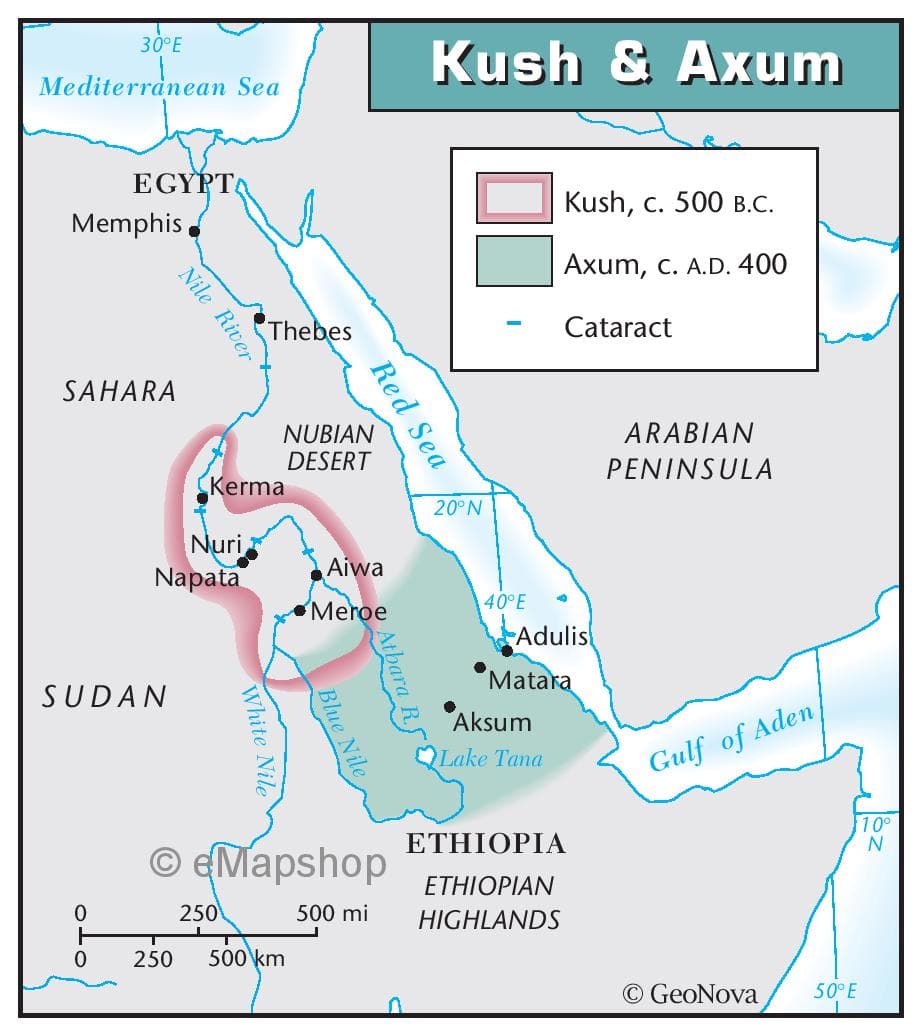
What is the purpose of the Kush & Axum map? State the purpose or intention of the map. Is it meant to provide directions, show demographics, display historical information, or illustrate a specific topic? This helps readers understand the map's objective.

Q: Analyze the impart of media censorship and control on the freedom of press and expression during the…
A: Media censorship and control during the Marcos years in the Philippines (1965–1986) had a profound…
Q: SELECT ALL THAT APPLY. In which stage(s) of the policymaking process are Congress and the president…
A: The policymaking process refers to the steps taken initiate reforms to address problems faced by the…
Q: 1. Match the people to their descriptions. 1. François de Barbé-Marbois 2. Napoleon 3. Meriwether…
A: In 1803 the US purchased a vast area of land from the French which doubled the size of the US and…
Q: What is the logic behind canto II, III, IV, in dantes inferno of their physical torment? That is,…
A: In Canto II, Dante is met by the spirit of Virgil, who is his guide through the underworld. In Canto…
Q: What landmark legislation was passed during Theodore Roosevelt
A: During Theodore Roosevelt presidency from 1901 to 1909, many landmark pieces of…
Q: What are the recommended books if you want to read world early history that are being used in…
A: Many people have an interest in reading about early world history, and they may wonder which books…
Q: SOURCE Roberts, Andrew. Napoleon: A Life. Viking, 2014. RESEARCH QUESTION "What were the…
A: The Book - Napoleon: A Life is written by Andrew Roberts is one of the bestseller all over the…
Q: Which of the following is NOT true regarding the Chicano and Chicana Movements of the 1970s? Group…
A: The Chicano Movement and Chicana Movement of the 1970s were civil rights movements that emerged…
Q: What was the result of the Marshall plan?
A: The US in the year 1948 launched an initiative known as the Marshall Plan which basically provided…
Q: Which of the following is NOT true regarding Ronald Reagan’s Immigration Reform and Control Act…
A: The 40th President of the United States of America, Ronald Reagan, was known to establish major…
Q: According to Peter Dunn, was the Vietnam War winnable? O No, since the North Vietnamese always…
A: Correct option is : 2 The question about Vietnam war winnable or not has been a topic of dialogue…
Q: ( Q.5 ) Louisiana Purchase : Question is provided in the photo below
A: The acquisition of the Louisiana Territory doubled the size of the United States and greatly…
Q: Find and include two image example of ancient Mesopotamian ziggurats.Explain/identify what…
A: Ziggurats are ancient stepped pyramid structures that were built in Mesopotamia, a region that is…
Q: SOURCE Schom, Alan. Napoleon Bonaparte: A Life. Harper Perennial, 1998. RESEARCH QUESTION…
A: Napoleon Bonaparte was the leader of France who emerged during the French Revolution and then became…
Q: 1. In the Old Testament we have stories of women portrayed in denigrated positions, as related in…
A: Throughout history, women have had a profound but often overlooked impact on society. Their…
Q: 1. What is the difference between limited and ttotal war? 2. What is a "world war," and other…
A: The study of history and international relations offers insights into not just the causes, results,…
Q: 1. Creole Louisiana a) How would you define Creole Louisiana? b) What are the foundations of…
A: Creole Louisiana has a rich history and culture that is deeply rooted in the region's unique…
Q: 4. The five men involved in the Watergate break-in had ties to and/or
A: The Watergate break-in was a political scandal that occurred in 1972, when five men broke into the…
Q: Source 7: U.N. Resolution 925 - Adopted by the Security Council at its 3388th meeting, on 8 June…
A: The United Nations Security Council is one of the six main organs of the United Nations, responsible…
Q: How do Faust and Williams argue how the Civil War impacted the lives of Americans?
A: On the subject of how the Civil War influenced American existence, Drew Gilpin Faust and David…
Q: riefly summarize the Mongol Khanates c. 1290 map. Make sure to includes the empires, routes of…
A: The Mongol Khanates map of c. 1290 illustrates the vast empire of the Mongol Empire at its height,…
Q: Briefly describe each period below and find and include 2 examples of art from each. Make sure you…
A: Art has been an important part of human life, since time immemorial and it has been evolving and…
Q: My Source: Bourrienne, Louis Antoine Fauvelet de. "Memoirs of Napoleon Bonaparte." London: Henry…
A: The Book - Memoirs of Napoleon Bonaparte was written by Louis Antoine Fauvelet de Bourrienne, a…
Q: Which of the following is true about signing statements? They can be issued by Congress. The…
A: A signing statement is a declaration bestowed by the President of America or a state governor at the…
Q: Name of the HBCU and year of its founding (2) Location of the HBCU (3) Prominent Alumni (4) What…
A: African Americans in the U.S. have a complex history marked by enslavement, racial segregation, and…
Q: 3. Which of the following was not one of Gerald Ford's challenges during his presidency?
A: Gerald Ford (1913-2006) was the 38th President of the United States, serving from 1974 to 1977. He…
Q: 38. Which of the following was not a scandal related to President Bill Clinton? Whitewater the…
A: Bill Clinton is a former American politician and attorney who served as the 42nd President of the…
Q: How does Michael Moore use logos in Fahrenheit 9/11
A: The 9/11 terrorist attacks occurred during the presidency of George W. Bush. The Bush administration…
Q: SOURCE Markham, Felix. Napoleon. University of Chicago Press, 1963. RESEARCH QUESTION…
A: Felix Markham, a British historian, and author who lived from 1908 to 1992, is most known for his…
Q: Find and include and identify three image examples of Assyrian ornament. What makes them Assyrian?
A: Assyrian ornamentation is a style of decoration that was used in art, architecture, and everyday…
Q: What are the foundations of Creole Louisiana history and culture?
A: Creole Louisiana is a region that has a rich history and culture, rooted in the colonial era of…
Q: The Walking Purchase - Help me, identify the impact of the Walking Purchase on Native American…
A: The Walking Purchase had a profound impact on Native American relations in Pennsylvania,…
Q: Examine the social, political, and economic impact of the Civil War on the North and the South.
A: The Civil War was one of the major conflicts. It had long lasting social, political and financial…
Q: The Green Revolution was masterminded by Jawaharlal Nehru and his grandson Rajiv Gandhi. doubled…
A: The Green Revolution was a period of agricultural transformation that occurred between 1960s and…
Q: illuminated manuscripts? During the Middle Ages, who made illuminated manuscripts and why? What is…
A: Illuminated manuscripts are Decorative handcrafted books with elaborate illustrations,…
Q: 9. Which of the following accurately describes the troop surge during the Iraq War?
A: The U.S. invasion of Iraq began in 2003, leading to a prolonged conflict that lasted for years. The…
Q: 2. Why did Robert E. Lee wish to push the Civil War farther north? O Lee hoped that a victory in the…
A: In the summer of 1862, Confederate General Robert E. Lee launched a series of invasions of the…
Q: On pages 89 to 92 of his article on the US in Vietnam, Peter Dunn describes operation "Cedar Falls."…
A: The Vietnam War was a significant event in world history, with long-lasting consequences for the…
Q: What is one policy that can be changed to benefit the war on drugs?
A: The "war on drugs" is a term used to describe the United States' government's efforts to combat drug…
Q: 34. Which of the following describes the lasting effects of the Watergate scandal on public opinion…
A: The Watergate scandal was a political scandal in the United States that occurred during the…
Q: What was the US civilization policy? What did the Five Civilized Tribes think was possible to attain…
A: The aspirations of the Five Civilized Tribes in their pursuit of civilization during a significant…
Q: Explain Pascal's reasons for thinking that we cannot opt out of wagering about God's existence.
A: Pascal's reasons for believing in God were more likely based on the benefits and outcome of it than…
Q: Minoan Arts: 1. In addition to a religious motif, what other motifs did the Minoans utilize?…
A: The Minoans, a Bronze Age civilization on the island of Crete, thrived from approximately 2700 to…
Q: what has charles done to modernize the coronation, king charles coronation 2023
A: King Charles III was crowned in London's Westminster Abbey on May 6, 2023. He was crowned as the…
Q: US Foreign Policy post WW II
A: The outbreak of globe War II in 1939 and its continuance until 1945 were witnessed by the whole…
Q: 1. Which of the following was not an argument supporting Nixon during the United States v. Nixon…
A: The United States v. Nixon was a Supreme Court case that was related to the Watergate Scandal and…
Q: What was the main goal of President Bill Clinton's Personal Responsibility and Work Opportunity…
A: Bill Clinton served as the 42nd President of the United States from 1993 to 2001. He implemented…
Q: we have looked at art from Prehistoric times up to the Middle Ages. The people who existed during…
A: Art has been a part of human culture for centuries. It has been used to express emotions, tell…
Q: The alternative style of the 1990s was a return to roots and was concevied as an "alternative" to…
A: During the 1980s, popular music was overwhelmed by polished and commercially thriving genres like…
Q: how china influenced the making of the modern world
A: Dating back over 5,000 years, China boasts a rich and multifarious past as one of the most ancient…
What is the purpose of the Kush & Axum map?
State the purpose or intention of the map. Is it meant to provide directions, show demographics, display historical information, or illustrate a specific topic? This helps readers understand the map's objective.

Step by step
Solved in 3 steps
