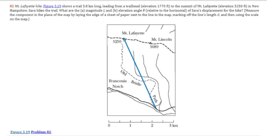
82 Mt. Lafayette hike. Eigure 3.19 shows a trail 5.8 km long, leading from a trailhead (elevation 1770 ft) to the summit of Mt. Lafayette (elevation 5250 ft) in New Hampshire. Sara hikes the trail. What are the (a) magnitude L and (b) elevation angle (relative to the horizontal) of Sara's displacement for the hike? (Measure the component in the plane of the map by laying the edge of a sheet of paper next to the line in the map, marking off the line's length d, and then using the scale on the map.)
82 Mt. Lafayette hike. Eigure 3.19 shows a trail 5.8 km long, leading from a trailhead (elevation 1770 ft) to the summit of Mt. Lafayette (elevation 5250 ft) in New Hampshire. Sara hikes the trail. What are the (a) magnitude L and (b) elevation angle (relative to the horizontal) of Sara's displacement for the hike? (Measure the component in the plane of the map by laying the edge of a sheet of paper next to the line in the map, marking off the line's length d, and then using the scale on the map.)

Related questions
Question
Transcribed Image Text:82 Mt. Lafayette hike. Figure 3.19 shows a trail 5.8 km long, leading from a trailhead (elevation 1770 ft) to the summit of Mt. Lafayette (elevation 5250 ft) in New
Hampshire. Sara hikes the trail. What are the (a) magnitude L and (b) elevation angle (relative to the horizontal) of Sara's displacement for the hike? (Measure
the component in the plane of the map by laying the edge of a sheet of paper next to the line in the map, marking off the line's length d, and then using the scale
on the map.)
Eigure 3.19 Problem 82.
5250
Mt. Lafayette
Old
Franconia
Notch
Bridle
Mt. Lincoln
5089
Path
2
3 km
Expert Solution
This question has been solved!
Explore an expertly crafted, step-by-step solution for a thorough understanding of key concepts.

This is a popular solution!

Trending now
This is a popular solution!

Step by step
Solved in 2 steps with 2 images
