A series of piezometers have been installed into a shallow, unconfined aquifer at and research watershed. You have been tasked with assessing the water table. Coordinates for the three piezometers are based on a cartesian grid of the research watershed. Positive Y values indicate North; negative Y values indicate South; positive X values are East; negative X values are West. Z values are the elevation of the water table. All coordinate values listed below are in meters and reported in order as X, Y, Z. • Piezometer 1: 3621m, 7838m, 1134m • Piezometer 2: 3621m, 7638m, 1124m • Piezometer 3: 3421m, 7838m, 1134m What is the groundwater flow direction and the slope (not dip) of the water table?
A series of piezometers have been installed into a shallow, unconfined aquifer at and research watershed. You have been tasked with assessing the water table. Coordinates for the three piezometers are based on a cartesian grid of the research watershed. Positive Y values indicate North; negative Y values indicate South; positive X values are East; negative X values are West. Z values are the elevation of the water table. All coordinate values listed below are in meters and reported in order as X, Y, Z. • Piezometer 1: 3621m, 7838m, 1134m • Piezometer 2: 3621m, 7638m, 1124m • Piezometer 3: 3421m, 7838m, 1134m What is the groundwater flow direction and the slope (not dip) of the water table?

Applications and Investigations in Earth Science (9th Edition)
9th Edition
ISBN:9780134746241
Author:Edward J. Tarbuck, Frederick K. Lutgens, Dennis G. Tasa
Publisher:Edward J. Tarbuck, Frederick K. Lutgens, Dennis G. Tasa
Chapter1: The Study Of Minerals
Section: Chapter Questions
Problem 1LR

Related questions
Question
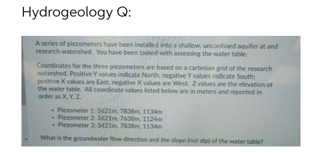
Transcribed Image Text:Hydrogeology Q:
A series of piezometers have been installed into a shallow, unconfined aquifer at and
research watershed. You have been tasked with assessing the water table.
Coordinates for the three piezometers are based on a cartesian grid of the research
watershed. Positive Y values indicate North; negative Y values indicate South;
positive X values are East; negative X values are West. Z values are the elevation of
the water table. All coordinate values listed below are in meters and reported in
order as X, Y, Z.
• Piezometer 1: 3621m, 7838m, 1134m
• Piezometer 2: 3621m, 7638m, 1124m
• Piezometer 3: 3421m, 7838m, 1134m
What is the groundwater flow direction and the slope (not dip) of the water table?
Expert Solution
This question has been solved!
Explore an expertly crafted, step-by-step solution for a thorough understanding of key concepts.

Step by step
Solved in 2 steps

Recommended textbooks for you
Applications and Investigations in Earth Science …
Earth Science
ISBN:
9780134746241
Author:
Edward J. Tarbuck, Frederick K. Lutgens, Dennis G. Tasa
Publisher:
PEARSON

Exercises for Weather & Climate (9th Edition)
Earth Science
ISBN:
9780134041360
Author:
Greg Carbone
Publisher:
PEARSON

Environmental Science
Earth Science
ISBN:
9781260153125
Author:
William P Cunningham Prof., Mary Ann Cunningham Professor
Publisher:
McGraw-Hill Education
Applications and Investigations in Earth Science …
Earth Science
ISBN:
9780134746241
Author:
Edward J. Tarbuck, Frederick K. Lutgens, Dennis G. Tasa
Publisher:
PEARSON
Exercises for Weather & Climate (9th Edition)
Earth Science
ISBN:
9780134041360
Author:
Greg Carbone
Publisher:
PEARSON
Environmental Science
Earth Science
ISBN:
9781260153125
Author:
William P Cunningham Prof., Mary Ann Cunningham Professor
Publisher:
McGraw-Hill Education

Earth Science (15th Edition)
Earth Science
ISBN:
9780134543536
Author:
Edward J. Tarbuck, Frederick K. Lutgens, Dennis G. Tasa
Publisher:
PEARSON

Environmental Science (MindTap Course List)
Earth Science
ISBN:
9781337569613
Author:
G. Tyler Miller, Scott Spoolman
Publisher:
Cengage Learning

Physical Geology
Earth Science
ISBN:
9781259916823
Author:
Plummer, Charles C., CARLSON, Diane H., Hammersley, Lisa
Publisher:
Mcgraw-hill Education,