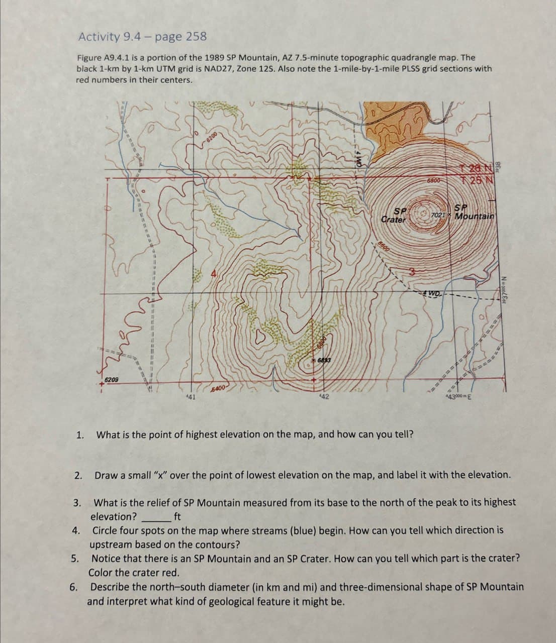
Activity 9.4-page 258 Figure A9.4.1 is a portion of the 1989 SP Mountain, AZ 7.5-minute topographic quadrangle map. The black 1-km by 1-km UTM grid is NAD27, Zone 125. Also note the 1-mile-by-1-mile PLSS grid sections with red numbers in their centers. 6200 6800 6893 6209 5400- 441 442 6800 T28 N 25 N SP Crater SP 7021 Mountain 6600 1. What is the point of highest elevation on the map, and how can you tell? WO +43000E 4. 5. Draw a small "x" over the point of lowest elevation on the map, and label it with the elevation. What is the relief of SP Mountain measured from its base to the north of the peak to its highest elevation? ft Circle four spots on the map where streams (blue) begin. How can you tell which direction is upstream based on the contours? Notice that there is an SP Mountain and an SP Crater. How can you tell which part is the crater? Color the crater red. 6. Describe the north-south diameter (in km and mi) and three-dimensional shape of SP Mountain and interpret what kind of geological feature it might be.
Activity 9.4-page 258 Figure A9.4.1 is a portion of the 1989 SP Mountain, AZ 7.5-minute topographic quadrangle map. The black 1-km by 1-km UTM grid is NAD27, Zone 125. Also note the 1-mile-by-1-mile PLSS grid sections with red numbers in their centers. 6200 6800 6893 6209 5400- 441 442 6800 T28 N 25 N SP Crater SP 7021 Mountain 6600 1. What is the point of highest elevation on the map, and how can you tell? WO +43000E 4. 5. Draw a small "x" over the point of lowest elevation on the map, and label it with the elevation. What is the relief of SP Mountain measured from its base to the north of the peak to its highest elevation? ft Circle four spots on the map where streams (blue) begin. How can you tell which direction is upstream based on the contours? Notice that there is an SP Mountain and an SP Crater. How can you tell which part is the crater? Color the crater red. 6. Describe the north-south diameter (in km and mi) and three-dimensional shape of SP Mountain and interpret what kind of geological feature it might be.

Applications and Investigations in Earth Science (9th Edition)
9th Edition
ISBN:9780134746241
Author:Edward J. Tarbuck, Frederick K. Lutgens, Dennis G. Tasa
Publisher:Edward J. Tarbuck, Frederick K. Lutgens, Dennis G. Tasa
Chapter1: The Study Of Minerals
Section: Chapter Questions
Problem 1LR

Related questions
Question
Transcribed Image Text:Activity 9.4-page 258
Figure A9.4.1 is a portion of the 1989 SP Mountain, AZ 7.5-minute topographic quadrangle map. The
black 1-km by 1-km UTM grid is NAD27, Zone 125. Also note the 1-mile-by-1-mile PLSS grid sections with
red numbers in their centers.
6200
6800
6893
6209
5400-
441
442
6800
T28 N
25 N
SP
Crater
SP
7021 Mountain
6600
1. What is the point of highest elevation on the map, and how can you tell?
WO
+43000E
4.
5.
Draw a small "x" over the point of lowest elevation on the map, and label it with the elevation.
What is the relief of SP Mountain measured from its base to the north of the peak to its highest
elevation?
ft
Circle four spots on the map where streams (blue) begin. How can you tell which direction is
upstream based on the contours?
Notice that there is an SP Mountain and an SP Crater. How can you tell which part is the crater?
Color the crater red.
6. Describe the north-south diameter (in km and mi) and three-dimensional shape of SP Mountain
and interpret what kind of geological feature it might be.
Expert Solution
This question has been solved!
Explore an expertly crafted, step-by-step solution for a thorough understanding of key concepts.

This is a popular solution!

Trending now
This is a popular solution!

Step by step
Solved in 2 steps with 1 images

Recommended textbooks for you
Applications and Investigations in Earth Science …
Earth Science
ISBN:
9780134746241
Author:
Edward J. Tarbuck, Frederick K. Lutgens, Dennis G. Tasa
Publisher:
PEARSON

Exercises for Weather & Climate (9th Edition)
Earth Science
ISBN:
9780134041360
Author:
Greg Carbone
Publisher:
PEARSON

Environmental Science
Earth Science
ISBN:
9781260153125
Author:
William P Cunningham Prof., Mary Ann Cunningham Professor
Publisher:
McGraw-Hill Education
Applications and Investigations in Earth Science …
Earth Science
ISBN:
9780134746241
Author:
Edward J. Tarbuck, Frederick K. Lutgens, Dennis G. Tasa
Publisher:
PEARSON
Exercises for Weather & Climate (9th Edition)
Earth Science
ISBN:
9780134041360
Author:
Greg Carbone
Publisher:
PEARSON
Environmental Science
Earth Science
ISBN:
9781260153125
Author:
William P Cunningham Prof., Mary Ann Cunningham Professor
Publisher:
McGraw-Hill Education

Earth Science (15th Edition)
Earth Science
ISBN:
9780134543536
Author:
Edward J. Tarbuck, Frederick K. Lutgens, Dennis G. Tasa
Publisher:
PEARSON

Environmental Science (MindTap Course List)
Earth Science
ISBN:
9781337569613
Author:
G. Tyler Miller, Scott Spoolman
Publisher:
Cengage Learning

Physical Geology
Earth Science
ISBN:
9781259916823
Author:
Plummer, Charles C., CARLSON, Diane H., Hammersley, Lisa
Publisher:
Mcgraw-hill Education,