DEPARTURES. Given in the accompanying tabulations are the observed data pertaining to four diffe- Compute and tabulate the latitudes and 6. LATITUDES AND rent traverses. departures of each course. AZIMUTH FROM SOUTH LINE LENGTH BEARING LINE DISTANCE N00° 42'E S85°57'E S03°04'w S52 51'w 242 30' 353 15 99 45' 154 00' AB 732.72m JK 430.05 m BC 324.78 KL 425.18 CD 477.24 LM 357.20 DA 388.08 MJ 183.18 AZIMUTH COURSE LENGTH COURSE LENGTH BEARING FROM NORTH 228 20' 267 43' 352°01' 82 12' 131 48' N59°33'E s39 18'E s06°35'w NI7 48'W N70 59'w 161.46 m i-2 2-3 427.00 m 1-2 2-3 180.49 301.95 3-4 171.83 3-4 445.66 4-5 229.70 4-5 326.73 5-1 130.55 5-1 434.50
DEPARTURES. Given in the accompanying tabulations are the observed data pertaining to four diffe- Compute and tabulate the latitudes and 6. LATITUDES AND rent traverses. departures of each course. AZIMUTH FROM SOUTH LINE LENGTH BEARING LINE DISTANCE N00° 42'E S85°57'E S03°04'w S52 51'w 242 30' 353 15 99 45' 154 00' AB 732.72m JK 430.05 m BC 324.78 KL 425.18 CD 477.24 LM 357.20 DA 388.08 MJ 183.18 AZIMUTH COURSE LENGTH COURSE LENGTH BEARING FROM NORTH 228 20' 267 43' 352°01' 82 12' 131 48' N59°33'E s39 18'E s06°35'w NI7 48'W N70 59'w 161.46 m i-2 2-3 427.00 m 1-2 2-3 180.49 301.95 3-4 171.83 3-4 445.66 4-5 229.70 4-5 326.73 5-1 130.55 5-1 434.50

Chapter2: Loads On Structures
Section: Chapter Questions
Problem 1P

Related questions

Question
fundamentals of
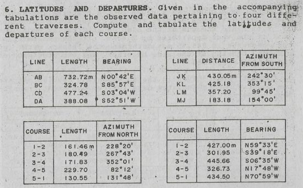
Transcribed Image Text:DEPARTURES. Given in the accompanying
tabulations are the observed data pertaining to four diffe-
Compute and tabulate the latitudes and
6. LATITUDES AND
rent traverses.
departures of each course.
AZIMUTH
FROM SOUTH
LINE
LENGTH
BEARING
LINE
DISTANCE
N00° 42'E
S85°57'E
S03°04'w
S52 51'w
242 30'
353 15
99 45'
154 00'
AB
732.72m
JK
430.05 m
BC
324.78
KL
425.18
CD
477.24
LM
357.20
DA
388.08
MJ
183.18
AZIMUTH
COURSE
LENGTH
COURSE
LENGTH
BEARING
FROM NORTH
228 20'
267 43'
352°01'
82 12'
131 48'
N59°33'E
s39 18'E
s06°35'w
NI7 48'W
N70 59'w
161.46 m
i-2
2-3
427.00 m
1-2
2-3
180.49
301.95
3-4
171.83
3-4
445.66
4-5
229.70
4-5
326.73
5-1
130.55
5-1
434.50
Expert Solution
This question has been solved!
Explore an expertly crafted, step-by-step solution for a thorough understanding of key concepts.

Step by step
Solved in 4 steps with 4 images

Knowledge Booster


Learn more about
Need a deep-dive on the concept behind this application? Look no further. Learn more about this topic, civil-engineering and related others by exploring similar questions and additional content below.Recommended textbooks for you

Structural Analysis (10th Edition)
Civil Engineering
ISBN:
9780134610672
Author:
Russell C. Hibbeler
Publisher:
PEARSON

Principles of Foundation Engineering (MindTap Cou…
Civil Engineering
ISBN:
9781337705028
Author:
Braja M. Das, Nagaratnam Sivakugan
Publisher:
Cengage Learning
Structural Analysis (10th Edition)
Civil Engineering
ISBN:
9780134610672
Author:
Russell C. Hibbeler
Publisher:
PEARSON
Principles of Foundation Engineering (MindTap Cou…
Civil Engineering
ISBN:
9781337705028
Author:
Braja M. Das, Nagaratnam Sivakugan
Publisher:
Cengage Learning

Fundamentals of Structural Analysis
Civil Engineering
ISBN:
9780073398006
Author:
Kenneth M. Leet Emeritus, Chia-Ming Uang, Joel Lanning
Publisher:
McGraw-Hill Education


Traffic and Highway Engineering
Civil Engineering
ISBN:
9781305156241
Author:
Garber, Nicholas J.
Publisher:
Cengage Learning