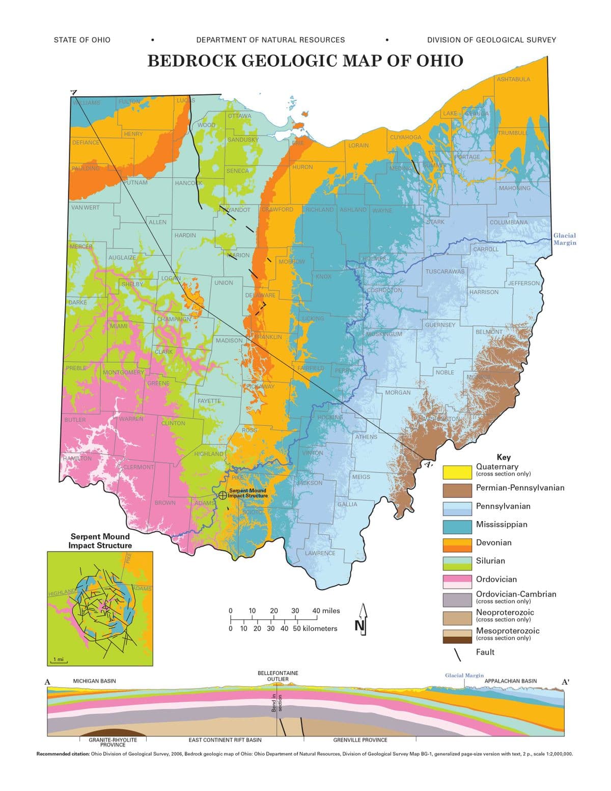
Find the blue line labeled “Glacial Margin” which goes from the northeast to the southwest of the state. This line represents the farthest advance of the glaciers which occupied Ohio during the last ice age (apprximately 20,000 years ago). Generally, are the rocks exposed north of the Glacial Margin are younger or older than the rocks exposed south of the glacial margin?
Find the blue line labeled “Glacial Margin” which goes from the northeast to the southwest of the state. This line represents the farthest advance of the glaciers which occupied Ohio during the last ice age (apprximately 20,000 years ago). Generally, are the rocks exposed north of the Glacial Margin are younger or older than the rocks exposed south of the glacial margin?

Applications and Investigations in Earth Science (9th Edition)
9th Edition
ISBN:9780134746241
Author:Edward J. Tarbuck, Frederick K. Lutgens, Dennis G. Tasa
Publisher:Edward J. Tarbuck, Frederick K. Lutgens, Dennis G. Tasa
Chapter1: The Study Of Minerals
Section: Chapter Questions
Problem 1LR

Related questions
Question
Find the blue line labeled “Glacial Margin” which goes from the northeast to the southwest of the state. This line represents the farthest advance of the glaciers which occupied Ohio during the last ice age (apprximately 20,000 years ago). Generally, are the rocks exposed north of the Glacial Margin are younger or older than the rocks exposed south of the glacial margin?
Transcribed Image Text:STATE OF OHIO
DEPARTMENT OF NATURAL RESOURCES
DIVISION OF GEOLOGICAL SURVEY
BEDROCK GEOLOGIC MAP OF OHIO
ASHTABULA
WWLLIAMS
FULTON
LUCAS
LAKE GEAUGAT
OTTAWA
WOOD
HENRY
TRUMBULL
CUYAHOGA
SANDUSKY
DEFIANCE
ERIE
LORAIN
PORTAGE
PAULDING
HURON
MEDINA
SUMMIT
SENECA
PUTNAM
HANCOCK
MAHONING
VAN WERT
YANDOT
CRAWFORD
RICHLAND ASHLAND WAYNE
ALLEN
STARK
COLUMBIANA
HARDIN
Glacial
Margin
MERCER
CARROLL
AUGLAIZE
NARION
HOLMES
МОBROW
TUSCARAWAS
LOGAN
KNOX
SHELBY
UNION
JEFFERSON
ACOSHOCTON
HARRISON
DELAWARE
DARKE
CHAMPAIGN
LICKING
MIAMI
GUERNSEY
MUSKINGUM
BELMONT
FRANKLIN
MADISON
CLARK
PREBLE
FAIRFIELD
PERRY
MONTGOMERY
NOBLE
MO
GREENE
PICKAWAY
MORGAN
FAYETTE
WARREN
HOCKING
WASFLINGTON
BUTLER
CLINTON
ROSS
ATHENS
HIGHLAND
VINTON
Key
Quaternary
(cross section only)
HAMILTON
CLERMONT
PIKE
MEIGS
|JACKSON
Permian-Pennsylvanian
Serpent Mound
Impact Structure
BROWN
ADAMS
GALLIA
Pennsylvanian
SCIOTO
Mississippian
Serpent Mound
Impact Structure
Devonian
LAWRENCE
Silurian
Ordovician
ADAMS
Ordovician-Cambrian
(cross section only)
HIGHLAND
10
20
30
40 miles
Neoproterozoic
(cross section only)
10 20 30 40 50 kilometers
Mesoproterozoic
(cross section only)
Fault
1 mi
BELLEFONTAINE
Glacial Margin
А
MICHIGAN BASIN
OUTLIER
APPALACHIAN BASIN
A'
GRANITE-RHYOLITE
PROVINCE
EAST CONTINENT RIFT BASIN
GRENVILLE PROVINCE
Recommended citation: Ohio Division of Geological Survey, 2006, Bedrock geologic map of Ohio: Ohio Department of Natural Resources, Division of Geological Survey Map BG-1, generalized page-size version with text, 2 p., scale 1:2,000,000.
PIKE
Bend in
section
Expert Solution
This question has been solved!
Explore an expertly crafted, step-by-step solution for a thorough understanding of key concepts.

This is a popular solution!

Trending now
This is a popular solution!

Step by step
Solved in 2 steps

Recommended textbooks for you
Applications and Investigations in Earth Science …
Earth Science
ISBN:
9780134746241
Author:
Edward J. Tarbuck, Frederick K. Lutgens, Dennis G. Tasa
Publisher:
PEARSON

Exercises for Weather & Climate (9th Edition)
Earth Science
ISBN:
9780134041360
Author:
Greg Carbone
Publisher:
PEARSON

Environmental Science
Earth Science
ISBN:
9781260153125
Author:
William P Cunningham Prof., Mary Ann Cunningham Professor
Publisher:
McGraw-Hill Education
Applications and Investigations in Earth Science …
Earth Science
ISBN:
9780134746241
Author:
Edward J. Tarbuck, Frederick K. Lutgens, Dennis G. Tasa
Publisher:
PEARSON
Exercises for Weather & Climate (9th Edition)
Earth Science
ISBN:
9780134041360
Author:
Greg Carbone
Publisher:
PEARSON
Environmental Science
Earth Science
ISBN:
9781260153125
Author:
William P Cunningham Prof., Mary Ann Cunningham Professor
Publisher:
McGraw-Hill Education

Earth Science (15th Edition)
Earth Science
ISBN:
9780134543536
Author:
Edward J. Tarbuck, Frederick K. Lutgens, Dennis G. Tasa
Publisher:
PEARSON

Environmental Science (MindTap Course List)
Earth Science
ISBN:
9781337569613
Author:
G. Tyler Miller, Scott Spoolman
Publisher:
Cengage Learning

Physical Geology
Earth Science
ISBN:
9781259916823
Author:
Plummer, Charles C., CARLSON, Diane H., Hammersley, Lisa
Publisher:
Mcgraw-hill Education,