How does ocean temperature at 2000 m depth (figure 3A-4) differ from surface ocean temperature (figure 3A-2)? a. it is warmer. b. it is colder. c. it remains unchanged.
How does ocean temperature at 2000 m depth (figure 3A-4) differ from surface ocean temperature (figure 3A-2)? a. it is warmer. b. it is colder. c. it remains unchanged.

Applications and Investigations in Earth Science (9th Edition)
9th Edition
ISBN:9780134746241
Author:Edward J. Tarbuck, Frederick K. Lutgens, Dennis G. Tasa
Publisher:Edward J. Tarbuck, Frederick K. Lutgens, Dennis G. Tasa
Chapter1: The Study Of Minerals
Section: Chapter Questions
Problem 1LR

Related questions
Question
How does ocean temperature at 2000 m depth (figure 3A-4) differ from surface ocean temperature (figure 3A-2)?
a. it is warmer.
b. it is colder.
c. it remains unchanged.
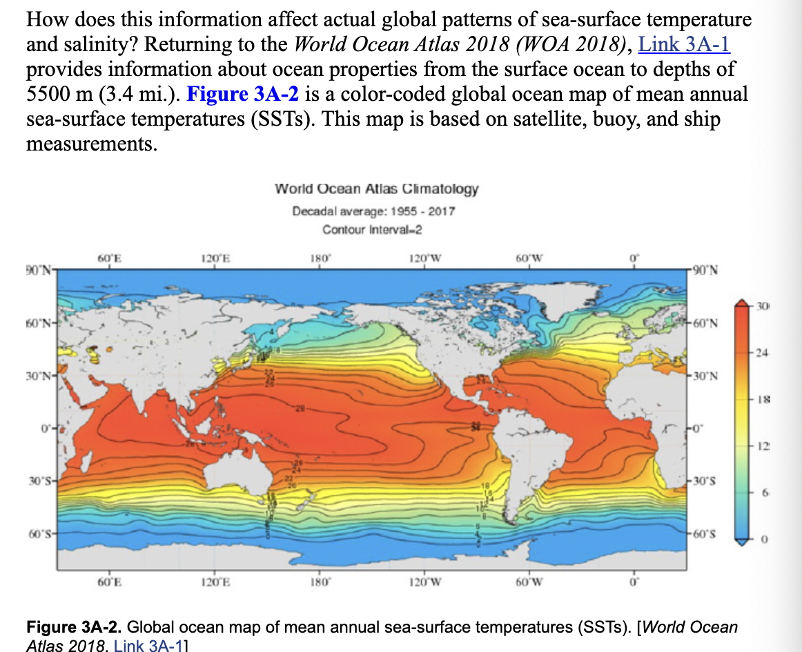
Transcribed Image Text:How does this information affect actual global patterns of sea-surface temperature
and salinity? Returning to the World Ocean Atlas 2018 (WOA 2018), Link 3A-1
provides information about ocean properties from the surface ocean to depths of
5500 m (3.4 mi.). Figure 3A-2 is a color-coded global ocean map of mean annual
sea-surface temperatures (SSTS). This map is based on satellite, buoy, and ship
measurements.
World Ocean Atlas Climatology
Decadal average: 1955 - 2017
Contour Interval-2
60'E
120'E
180
120'W
60'W
90°N-
N.06-
30
60'N-
+60°N
24
30'N-
30 N
18
12
30°S-
-30'S
6.
60°S-
60'S
60'E
120'E
180
120 W
60 W
Figure 3A-2. Global ocean map of mean annual sea-surface temperatures (SSTS). [World Ocean
Atlas 2018. Link 3A-11
![To understand more about vertical ocean properties, the WOA 2018 also has water
property maps that can be created at a particular depth in the ocean. Figure 3A-4 is
a color-coded global ocean map of mean annual temperatures at a depth of 2000 m.
Temperature is measured in degrees Celsius at 0.5°C contours.
World Ocean Atlas Climatology
Decadal average: 1955 - 2017
Contour Interval-0.25
60'E
120'E
180
120'W
60'W
90'N-
90'
60'N-
60'N
30'N-
30'N
30'S-
30'S
60'S-
60'S
60'E
120'E
180
120'W
60'W
Annual temperature [°C] at 2000 m. depth (one-degree grid)
Figure 3A-4. Global ocean map of mean annual temperature at 2000 m. [World Ocean Atlas 2018,
Link 3A-11](/v2/_next/image?url=https%3A%2F%2Fcontent.bartleby.com%2Fqna-images%2Fquestion%2F03b1462a-0e5a-4a37-baae-06e9953f8b62%2F08ebdbbc-682b-48d0-b8fd-d0baf10ed2d7%2Ffealm3m_processed.png&w=3840&q=75)
Transcribed Image Text:To understand more about vertical ocean properties, the WOA 2018 also has water
property maps that can be created at a particular depth in the ocean. Figure 3A-4 is
a color-coded global ocean map of mean annual temperatures at a depth of 2000 m.
Temperature is measured in degrees Celsius at 0.5°C contours.
World Ocean Atlas Climatology
Decadal average: 1955 - 2017
Contour Interval-0.25
60'E
120'E
180
120'W
60'W
90'N-
90'
60'N-
60'N
30'N-
30'N
30'S-
30'S
60'S-
60'S
60'E
120'E
180
120'W
60'W
Annual temperature [°C] at 2000 m. depth (one-degree grid)
Figure 3A-4. Global ocean map of mean annual temperature at 2000 m. [World Ocean Atlas 2018,
Link 3A-11
Expert Solution
This question has been solved!
Explore an expertly crafted, step-by-step solution for a thorough understanding of key concepts.

This is a popular solution!

Trending now
This is a popular solution!

Step by step
Solved in 3 steps with 1 images

Recommended textbooks for you
Applications and Investigations in Earth Science …
Earth Science
ISBN:
9780134746241
Author:
Edward J. Tarbuck, Frederick K. Lutgens, Dennis G. Tasa
Publisher:
PEARSON

Exercises for Weather & Climate (9th Edition)
Earth Science
ISBN:
9780134041360
Author:
Greg Carbone
Publisher:
PEARSON

Environmental Science
Earth Science
ISBN:
9781260153125
Author:
William P Cunningham Prof., Mary Ann Cunningham Professor
Publisher:
McGraw-Hill Education
Applications and Investigations in Earth Science …
Earth Science
ISBN:
9780134746241
Author:
Edward J. Tarbuck, Frederick K. Lutgens, Dennis G. Tasa
Publisher:
PEARSON
Exercises for Weather & Climate (9th Edition)
Earth Science
ISBN:
9780134041360
Author:
Greg Carbone
Publisher:
PEARSON
Environmental Science
Earth Science
ISBN:
9781260153125
Author:
William P Cunningham Prof., Mary Ann Cunningham Professor
Publisher:
McGraw-Hill Education

Earth Science (15th Edition)
Earth Science
ISBN:
9780134543536
Author:
Edward J. Tarbuck, Frederick K. Lutgens, Dennis G. Tasa
Publisher:
PEARSON

Environmental Science (MindTap Course List)
Earth Science
ISBN:
9781337569613
Author:
G. Tyler Miller, Scott Spoolman
Publisher:
Cengage Learning

Physical Geology
Earth Science
ISBN:
9781259916823
Author:
Plummer, Charles C., CARLSON, Diane H., Hammersley, Lisa
Publisher:
Mcgraw-hill Education,