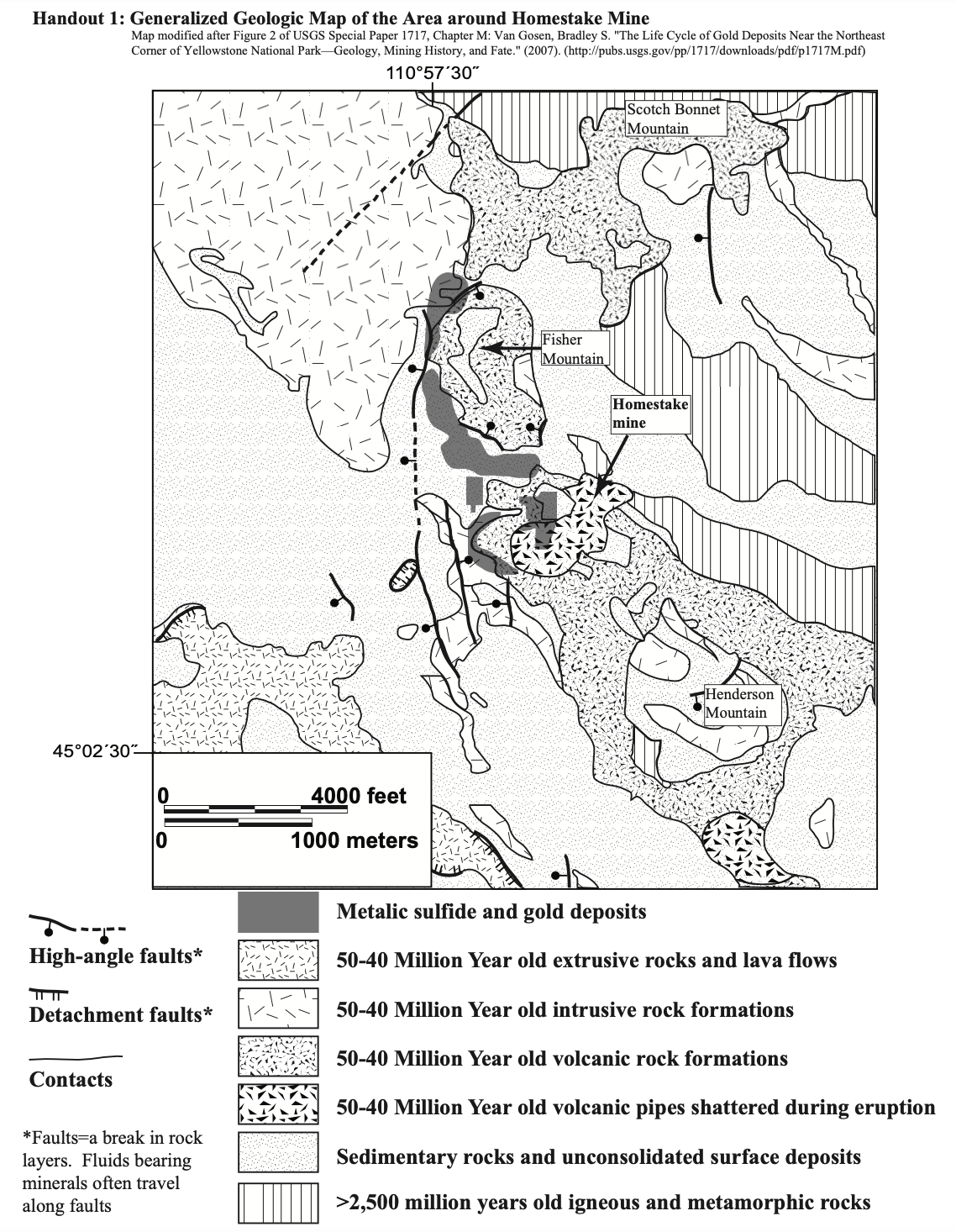
Handout 1: Generalized Geologic Map of the Area around Homestake Mine Map modified after Figure 2 of USGS Special Paper 1717, Chapter M: Van Gosen, Bradley S. "The Life Cycle of Gold Deposits Near the Northeast Corner of Yellowstone National Park–Geology, Mining History, and Fate." (2007). (http://pubs.usgs.gov/pp/1717/downloads/pdf/p1717M.pdf) 110°57'30" Scotch Bonnet Mountain Fisher Mountain Homestake mine Henderson Mountain 45°02'30" 4000 feet 1000 meters Metalic sulfide and gold deposits High-angle faults* 50-40 Million Year old extrusive rocks and lava flows Detachment faults* 50-40 Million Year old intrusive rock formations 50-40 Million Year old volcanic rock formations Contacts 50-40 Million Year old volcanic pipes shattered during eruption *Faults=a break in rock Sedimentary rocks and unconsolidated surface deposits layers. Fluids bearing minerals often travel along faults >2,500 million years old igneous and metamorphic rocks
Oh no! Our experts couldn't answer your question.
Don't worry! We won't leave you hanging. Plus, we're giving you back one question for the inconvenience.
4) Now look at the high-angle faults shown in the map. Faults often provide pathways for fluids bearing metallic minerals. What is the spatial relationship between the high angle faults and the metallic sulfide and gold deposits? Note: consider "close" to mean within ~500 m.
5) Based on this geologic map and your answer to the question above, what locations are reasonable places to look for similar deposits? Base your answer on whether the rocks that might house those deposits and/or faults that might carry the mineral-bearing fluids are present.
6) The area around Homestake Mine, Montana, is currently under a “no-mining” rule. In the future, there is a high probability that this region will see active mining once again.
There is a high likelihood of earthquakes in this region due to the igneous activity under Yellowstone National Park, and while most of the earthquakes are small, there have been some large earthquakes (such as a magnitude 7.3 in 1959) in the region. What type(s) of environmental concern(s)/hazards would a large earthquake pose to a mine? Explain your answer.