One hundred years ago, a high plains area near the continental divide in Colorado was used as a working ranch. The views were majestic, although the winters could be harsh. As a result of the boom in skiing, snowmobiling, and other winter sports, the area quickly became a major tourist attraction. The result was a higher population base to support tourism and increased property values. During the late 1960s and 1970s, the area experienced dramatic growth. Many people from states such as Oklahoma and Texas vacationed here, and so purchased land, houses, or condominiums. Many property developers who finished their projects before the mid-1980s and early 1990s did very well financially. The success of other developers led to the organization of the Ranch Development Project. The Ranch Development Project was undertaken by two real estate companies in the Colorado high country and several investors from Oklahoma. The idea was to convert the working ranch into a luxury single-family development. The project became known as The Ranch. The average home price was $475,000, and it was not uncommon to have homes valued at more than $1 million. The center of the development was a first-class 18-hole golf course. Green fees could approach $100 per day, depending on services required. Some have claimed that the course is one of the best in Colorado. The Ranch also had a four-star restaurant located in a beautiful and spacious log cabin, which included a fireplace big enough for a 6-foot-tall person to walk into without hitting his head. Other amenities included a heated pool, lighted tennis courts, and a complete workout center. Free shuttle service was provided to the ski slopes a few miles away. To preserve the beauty of the area and to enhance property values, each home site varied from 1 acre to more than 20 acres. There were numerous building restrictions. Every home and structure had to be approved by the Ranch Development Board. Approval required developing a scale model of all buildings on the property and a complete set of blueprints. The average cost of preparing the necessary plans was $25,000. The concept of a footprint was also used. A footprint is a relatively small circular area on each plot of land. Homes and all structures had to be placed inside the footprint. Although the homeowner held title to the entire property, all structures had to be placed in the footprint unless special permission was given by the Ranch Development Board (a rare occurrence). Each homeowner had to pay monthly fees, depending on the location and value of the land. The fees could vary from $450 to more than $1,250 per month. These fees included water, sewer, cable TV, and access to the pool, tennis courts, and exercise facility. Golf and restaurant fees were additional. One of the developments in The Ranch is outlined in the figure below this problem. The development was not as close to the golf course as some of the others, but it had a beautiful trout stream and pond in the center. The footprints are shown in the network. Distances between footprints are given in hundreds of feet. Requirements: 1) Determine the least expensive way to connect all the homes with water and sewer lines. Assume that minimizing total distance will also minimize total costs. HINT: Type in the total minimum distance to connect nodes and how the nodes connect. 2) The Ranch Development Board is considering the possibility of expanding the pond area. This would allow for boating, including sailing and water skiing. This would increase property values, but some distances would change. The distance for path 11–16 would be 9, and the distance for path 16–22 would be 12. What impact would this have on the plan for the water and sewer system? HINT: Compute for a new optimal solution, then discuss the impact. Type it in! 3) Do you think it's worth it to expand the pond area? Explain your answer. Recommend a strategy for the Ranch Development Board.


One hundred years ago, a high plains area near the continental divide in Colorado was used as a working ranch. The views were majestic, although the winters could be harsh. As a result of the boom in skiing, snowmobiling, and other winter sports, the area quickly became a major tourist attraction. The result was a higher population base to support tourism and increased property values. During the late 1960s and 1970s, the area experienced dramatic growth. Many people from states such as Oklahoma and Texas vacationed here, and so purchased land, houses, or condominiums. Many property developers who finished their projects before the mid-1980s and early 1990s did very well financially. The success of other developers led to the organization of the Ranch Development Project.
The Ranch Development Project was undertaken by two real estate companies in the Colorado high country and several investors from Oklahoma. The idea was to convert the working ranch into a luxury single-family development. The project became known as The Ranch. The average home price was $475,000, and it was not uncommon to have homes valued at more than $1 million. The center of the development was a first-class 18-hole golf course. Green fees could approach $100 per day, depending on services required. Some have claimed that the course is one of the best in Colorado. The Ranch also had a four-star restaurant located in a beautiful and spacious log cabin, which included a fireplace big enough for a 6-foot-tall person to walk into without hitting his head. Other amenities included a heated pool, lighted tennis courts, and a complete workout center. Free shuttle service was provided to the ski slopes a few miles away.
To preserve the beauty of the area and to enhance property values, each home site varied from 1 acre to more than 20 acres. There were numerous building restrictions. Every home and structure had to be approved by the Ranch Development Board. Approval required developing a scale model of all buildings on the property and a complete set of blueprints. The average cost of preparing the necessary plans was $25,000. The concept of a footprint was also used. A footprint is a relatively small circular area on each plot of land. Homes and all structures had to be placed inside the footprint. Although the homeowner held title to the entire property, all structures had to be placed in the footprint unless special permission was given by the Ranch Development Board (a rare occurrence).
Each homeowner had to pay monthly fees, depending on the location and value of the land. The fees could vary from $450 to more than $1,250 per month. These fees included water, sewer, cable TV, and access to the pool, tennis courts, and exercise facility. Golf and restaurant fees were additional.
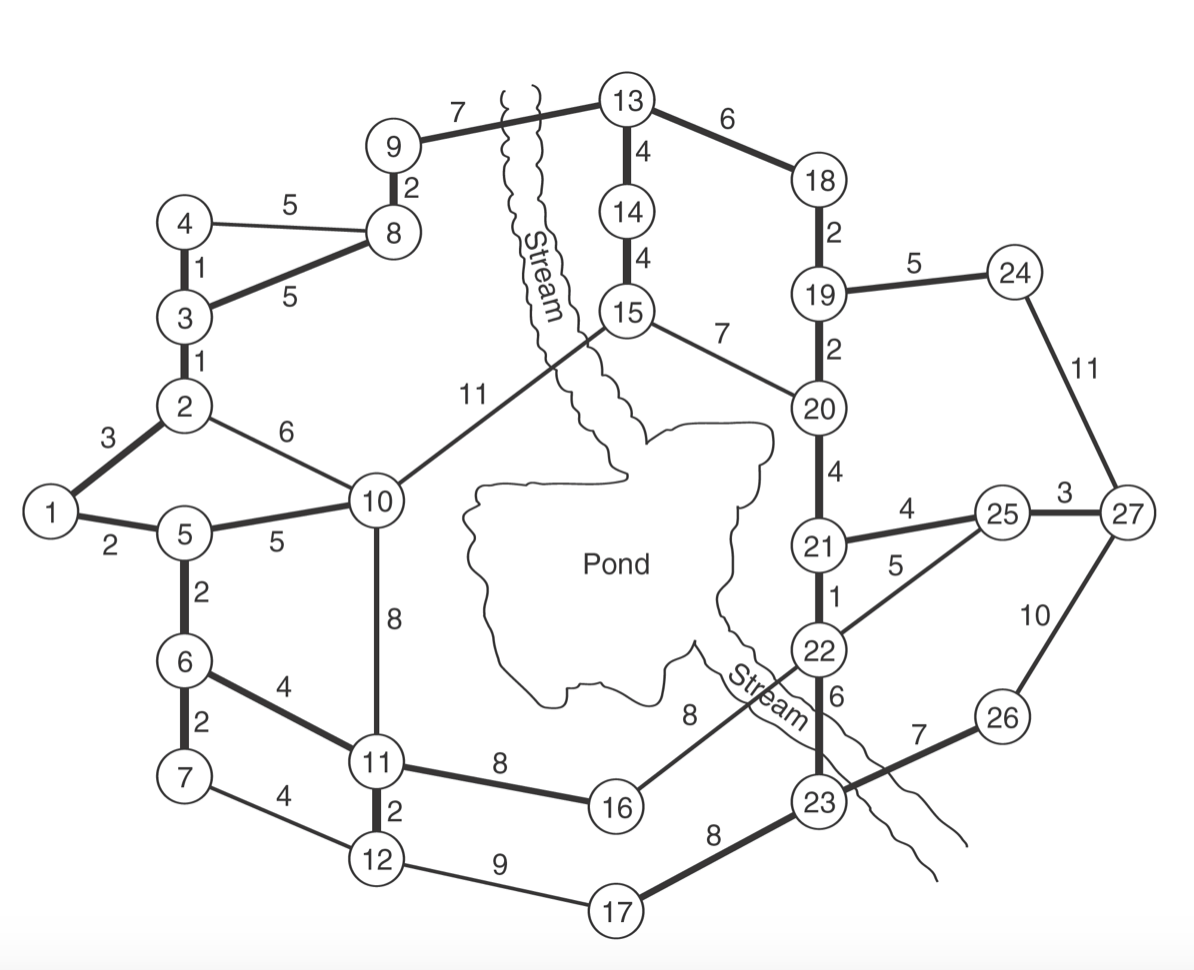
One of the developments in The Ranch is outlined in the figure below this problem. The development was not as close to the golf course as some of the others, but it had a beautiful trout stream and pond in the center. The footprints are shown in the network. Distances between footprints are given in hundreds of feet.
Requirements:
1) Determine the least expensive way to connect all the homes with water and sewer lines. Assume that minimizing total distance will also minimize total costs.
- HINT: Type in the total minimum distance to connect nodes and how the nodes connect.
2) The Ranch Development Board is considering the possibility of expanding the pond area. This would allow for boating, including sailing and water skiing. This would increase property values, but some distances would change. The distance for path 11–16 would be 9, and the distance for path 16–22 would be 12. What impact would this have on the plan for the water and sewer system?
- HINT: Compute for a new optimal solution, then discuss the impact. Type it in!
3) Do you think it's worth it to expand the pond area? Explain your answer. Recommend a strategy for the Ranch Development Board.


Trending now
This is a popular solution!

Step by step
Solved in 2 steps with 1 images


