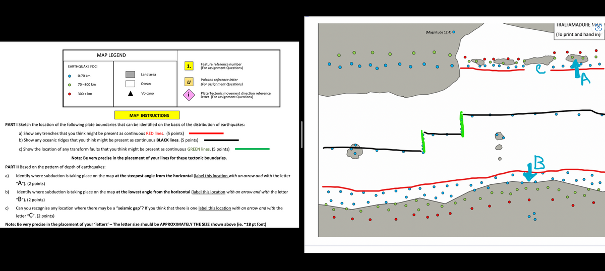
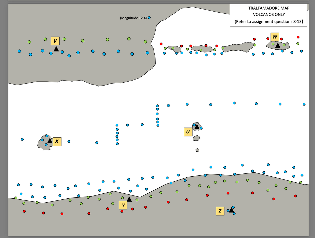
QUESTION 24 Which of the feature localities labelled on the Tralfamadore map would you most TYPICALLY find Pahoehoe? 2 answers A) U B) V C) W D) X E) Y F) Z QUESTION 25 Which of the following statements is FALSE regarding the Volcano’s found on the Tralfamadore map? A) The Basaltic type volcano(s) are high in iron and low in potassium, AND have Temperatures (in degrees Celsius) that range from 1000-1200 B) The Andesitic type volcano(s) have 55-65% SiO2 AND have an intermediate viscosity C) The Granitic type volcano(s) are low in iron and high in potassium, AND have a high Gas content D) The Basaltic type volcano(s) have 45-55% SiO2, AND have low Gas content E) The Andesitic type volcano(s) have Intermediate magnesium and sodium chemical composition AND have Temperatures (in degrees Celsius) that range from 800 -1000 F) The Granitic type volcano(s) have 65-85% SiO2 AND have Temperatures (in degrees Celsius) that range from 600 - 1200 QUESTION 26 The inhabitants of Tralfamadore are concerned about their health and safety because of the volcanic gases that may be emitted by the various volcanoes in the area depicted on the map provided. Which volcano should they be most concerned about in terms of their direct health and safety? A) Volcano located at a convergent margin, since it emits the largest proportion of Water vapour which can displace the oxygen we need for respiration. B) Volcano located at a divergent margin, since it emits the largest proportion of sulphur dioxide which can seep into the soil in high enough amounts to kill trees and small animals C) Volcano located at a hotspot, since it emits the largest proportion of hydrogen fluoride which can displace the oxygen we need for respiration. D) Volcano located at a convergent margin, since it emits the largest proportion of Hydrogen chloride which can produce a haze that can last for months and kill livestock. E) Volcano located at a Divergent margin, since it emits the largest proportion of Hydrogen which can cause an increase in global temperatures as a greenhouse gas. F) Volcano located at a hotspot, since it emits the largest proportion of Carbon monoxide which is one of the volcanic gasses that can cause the greatest number of fatalities. QUESTION 27 The inhabitants of Tralfamadore are concerned about their future well-being and would like to monitor certain areas more closely. Which area do you suggest they focus their limited resources to monitor for potential future disasters? A) Location 2 as a Magnitude 12.4 earthquake has occurred here and could very likely occur again. B) Location “v” as the direction of plate movement suggests that the plate could continue moving well into the future. C) Location U as this is a location of a potentially deadly Stratovolcano D) Location ‘’Z’’ as this is potentially the location of a ‘’supervolcano’’ similar to the area near Yellowstone National Park. E) None of the localities on the Tralfamadore map should be monitored as they present no future danger


QUESTION 24 Which of the feature localities labelled on the Tralfamadore map would you most TYPICALLY find Pahoehoe? 2 answers
A) U
B) V
C) W
D) X
E) Y
F) Z
QUESTION 25 Which of the following statements is FALSE regarding the Volcano’s found on the Tralfamadore map?
-
A) The Basaltic type volcano(s) are high in iron and low in potassium, AND have Temperatures (in degrees Celsius) that range from 1000-1200
-
B) The Andesitic type volcano(s) have 55-65% SiO2 AND have an intermediate viscosity
-
C) The Granitic type volcano(s) are low in iron and high in potassium, AND have a high Gas
content
-
D) The Basaltic type volcano(s) have 45-55% SiO2, AND have low Gas content
-
E) The Andesitic type volcano(s) have Intermediate magnesium and sodium chemical
composition AND have Temperatures (in degrees Celsius) that range from 800 -1000
-
F) The Granitic type volcano(s) have 65-85% SiO2 AND have Temperatures (in degrees Celsius)
that range from 600 - 1200
QUESTION 26 The inhabitants of Tralfamadore are concerned about their health and safety because of the volcanic gases that may be emitted by the various volcanoes in the area depicted on the map provided. Which volcano should they be most concerned about in terms of their direct health and safety?
-
A) Volcano located at a convergent margin, since it emits the largest proportion of Water vapour which can displace the oxygen we need for respiration.
-
B) Volcano located at a divergent margin, since it emits the largest proportion of sulphur dioxide which can seep into the soil in high enough amounts to kill trees and small animals
-
C) Volcano located at a hotspot, since it emits the largest proportion of hydrogen fluoride which can displace the oxygen we need for respiration.
-
D) Volcano located at a convergent margin, since it emits the largest proportion of Hydrogen chloride which can produce a haze that can last for months and kill livestock.
-
E) Volcano located at a Divergent margin, since it emits the largest proportion of Hydrogen which can cause an increase in global temperatures as a greenhouse gas.
-
F) Volcano located at a hotspot, since it emits the largest proportion of Carbon monoxide which is one of the volcanic gasses that can cause the greatest number of fatalities.
QUESTION 27 The inhabitants of Tralfamadore are concerned about their future well-being and would like to monitor certain areas more closely. Which area do you suggest they focus their limited resources to monitor for potential future disasters?
A) Location 2 as a Magnitude 12.4 earthquake has occurred here and could very likely occur again.
-
B) Location “v” as the direction of plate movement suggests that the plate could continue moving well into the future.
-
C) Location U as this is a location of a potentially deadly Stratovolcano
-
D) Location ‘’Z’’ as this is potentially the location of a ‘’supervolcano’’ similar to the area
near Yellowstone National Park.
-
E) None of the localities on the Tralfamadore map should be monitored as they present no
future danger

Step by step
Solved in 4 steps

For solution 24, you said "Solution 24:- Options (A), (C) are correct => U, W and X" but Options A and C is only letters U and W... Why X? And is options a and c the only right answer??


