The Weather Monitor. Your South American expedition splits into two groups: one that stays at home base, and yours that goes off set up a sensor that will monitor precipitation, temperature, and sunlight through the upcoming winter. The sensor must link up to a central communications system at base camp that simultaneously uploads the data from numerous sensors to a satellite. In order to set up and calibrate the sensor, you will have to communicate with base camp to give them specific location information. Unfortunately, the group's communication and navigation equipment has dwindled to walkie-talkies and a compass due to a river-raf mishap, which means your group must not exceed the range of the walkie-talkies (3.0 miles). However, you do have a laser rangefinde to help you measure distances as you navigate with the compass. After a few hours of hiking, you find the perfect plateau on which to mount the sensor. You have carefully mapped your path from base camp around lakes and other obstacles: 580 m West (W), 245 m S 740 m W, 980 m NE, 760 m W, and 410 m 30.0° W of S. The final leg is due south, 2.50 km up a constant slope and ending at a plateau that is h=370 m above the level of base camp. (a) How far are you from base camp? Will you be able to communicate with home base using the walkie-talkies? (b) What is the geographical direction from base camp to the sensor (expressed in the form 8° south of west, etc.)? (c) What is the angle of inclination from base camp to the detector? (a) Number (b) Number (c) Number i i i eTextbook and Media Units Units Units No units No units O Assistance Used Attempts: 1 of 5 used Submit Answer
The Weather Monitor. Your South American expedition splits into two groups: one that stays at home base, and yours that goes off set up a sensor that will monitor precipitation, temperature, and sunlight through the upcoming winter. The sensor must link up to a central communications system at base camp that simultaneously uploads the data from numerous sensors to a satellite. In order to set up and calibrate the sensor, you will have to communicate with base camp to give them specific location information. Unfortunately, the group's communication and navigation equipment has dwindled to walkie-talkies and a compass due to a river-raf mishap, which means your group must not exceed the range of the walkie-talkies (3.0 miles). However, you do have a laser rangefinde to help you measure distances as you navigate with the compass. After a few hours of hiking, you find the perfect plateau on which to mount the sensor. You have carefully mapped your path from base camp around lakes and other obstacles: 580 m West (W), 245 m S 740 m W, 980 m NE, 760 m W, and 410 m 30.0° W of S. The final leg is due south, 2.50 km up a constant slope and ending at a plateau that is h=370 m above the level of base camp. (a) How far are you from base camp? Will you be able to communicate with home base using the walkie-talkies? (b) What is the geographical direction from base camp to the sensor (expressed in the form 8° south of west, etc.)? (c) What is the angle of inclination from base camp to the detector? (a) Number (b) Number (c) Number i i i eTextbook and Media Units Units Units No units No units O Assistance Used Attempts: 1 of 5 used Submit Answer

Applications and Investigations in Earth Science (9th Edition)
9th Edition
ISBN:9780134746241
Author:Edward J. Tarbuck, Frederick K. Lutgens, Dennis G. Tasa
Publisher:Edward J. Tarbuck, Frederick K. Lutgens, Dennis G. Tasa
Chapter1: The Study Of Minerals
Section: Chapter Questions
Problem 1LR

Related questions
Question
Please answer/ show me steps to part A, B, and C.
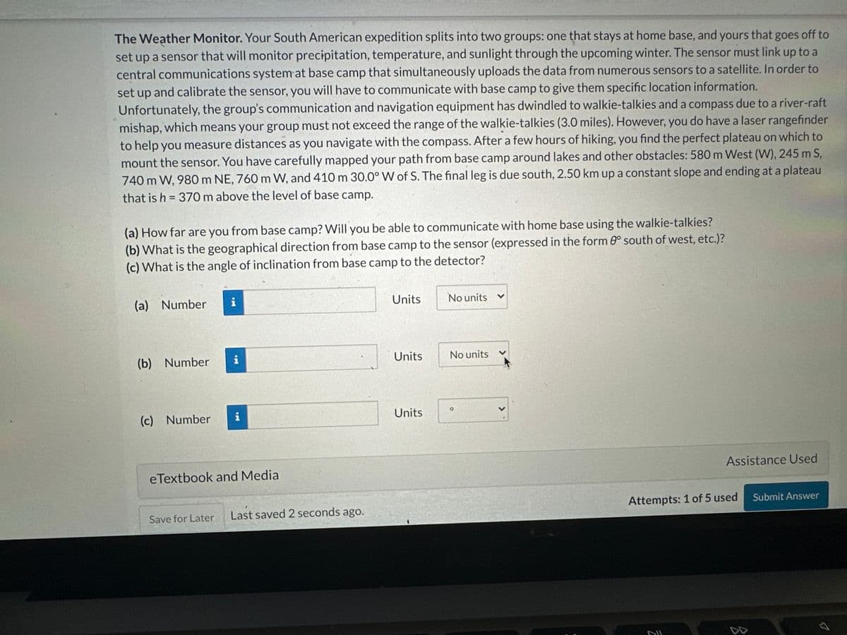
Transcribed Image Text:The Weather Monitor. Your South American expedition splits into two groups: one that stays at home base, and yours that goes off to
set up a sensor that will monitor precipitation, temperature, and sunlight through the upcoming winter. The sensor must link up to a
central communications system at base camp that simultaneously uploads the data from numerous sensors to a satellite. In order to
set up and calibrate the sensor, you will have to communicate with base camp to give them specific location information.
Unfortunately, the group's communication and navigation equipment has dwindled to walkie-talkies and a compass due to a river-raft
mishap, which means your group must not exceed the range of the walkie-talkies (3.0 miles). However, you do have a laser rangefinder
to help you measure distances as you navigate with the compass. After a few hours of hiking, you find the perfect plateau on which to
mount the sensor. You have carefully mapped your path from base camp around lakes and other obstacles: 580 m West (W), 245 m S,
740 m W, 980 m NE, 760 m W, and 410 m 30.0° W of S. The final leg is due south, 2.50 km up a constant slope and ending at a plateau
that is h = 370 m above the level of base camp.
(a) How far are you from base camp? Will you be able to communicate with home base using the walkie-talkies?
(b) What is the geographical direction from base camp to the sensor (expressed in the form 0° south of west, etc.)?
(c) What is the angle of inclination from base camp to the detector?
(a) Number i
(b) Number
(c) Number
i
eTextbook and Media
Save for Later
Last saved 2 seconds ago.
Units
Units
Units
No units
No units
Assistance Used
Attempts: 1 of 5 used
DUL
Submit Answer
Expert Solution
This question has been solved!
Explore an expertly crafted, step-by-step solution for a thorough understanding of key concepts.

This is a popular solution!

Trending now
This is a popular solution!

Step by step
Solved in 3 steps

Recommended textbooks for you
Applications and Investigations in Earth Science …
Earth Science
ISBN:
9780134746241
Author:
Edward J. Tarbuck, Frederick K. Lutgens, Dennis G. Tasa
Publisher:
PEARSON

Exercises for Weather & Climate (9th Edition)
Earth Science
ISBN:
9780134041360
Author:
Greg Carbone
Publisher:
PEARSON

Environmental Science
Earth Science
ISBN:
9781260153125
Author:
William P Cunningham Prof., Mary Ann Cunningham Professor
Publisher:
McGraw-Hill Education
Applications and Investigations in Earth Science …
Earth Science
ISBN:
9780134746241
Author:
Edward J. Tarbuck, Frederick K. Lutgens, Dennis G. Tasa
Publisher:
PEARSON
Exercises for Weather & Climate (9th Edition)
Earth Science
ISBN:
9780134041360
Author:
Greg Carbone
Publisher:
PEARSON
Environmental Science
Earth Science
ISBN:
9781260153125
Author:
William P Cunningham Prof., Mary Ann Cunningham Professor
Publisher:
McGraw-Hill Education

Earth Science (15th Edition)
Earth Science
ISBN:
9780134543536
Author:
Edward J. Tarbuck, Frederick K. Lutgens, Dennis G. Tasa
Publisher:
PEARSON

Environmental Science (MindTap Course List)
Earth Science
ISBN:
9781337569613
Author:
G. Tyler Miller, Scott Spoolman
Publisher:
Cengage Learning

Physical Geology
Earth Science
ISBN:
9781259916823
Author:
Plummer, Charles C., CARLSON, Diane H., Hammersley, Lisa
Publisher:
Mcgraw-hill Education,