Topographic Maps EXERCISE 1 DATA SHEET 1. What is the approximate elevation of Wonderland Lake? Explain your reaso 2. What is the elevation of the peak of Poorman Hill (near the western border o midway between north and south)? Explain your reasoning. 3. Boulder Creek is just south of Poorman Hill. Which is steeper: the banks of th the area close to the peak of Poorman Hill? Explain your reasoning. 4. You decide to walk from the top of Poorman Hill to Boulder Creek directly sout the relief of this walk? Sketch your path on the map, and show your calculation Be sure to take a picture of your path, and include it in your response. 5. When taking into account the horizontal distance (from the map scale) and the distance (relief), what is the total distance of your walk in question 4? Show you calculations below (Hint: use the Pythagorean Theorem, a? + b2 = c2). 6. Standing on the peak of Poorman Hill, you decide to walk to the intersection of Lane and Broadway. Trace the easiest route on the map, and explain your reas Take a picture of your route, and include it in your response.
Topographic Maps EXERCISE 1 DATA SHEET 1. What is the approximate elevation of Wonderland Lake? Explain your reaso 2. What is the elevation of the peak of Poorman Hill (near the western border o midway between north and south)? Explain your reasoning. 3. Boulder Creek is just south of Poorman Hill. Which is steeper: the banks of th the area close to the peak of Poorman Hill? Explain your reasoning. 4. You decide to walk from the top of Poorman Hill to Boulder Creek directly sout the relief of this walk? Sketch your path on the map, and show your calculation Be sure to take a picture of your path, and include it in your response. 5. When taking into account the horizontal distance (from the map scale) and the distance (relief), what is the total distance of your walk in question 4? Show you calculations below (Hint: use the Pythagorean Theorem, a? + b2 = c2). 6. Standing on the peak of Poorman Hill, you decide to walk to the intersection of Lane and Broadway. Trace the easiest route on the map, and explain your reas Take a picture of your route, and include it in your response.

Applications and Investigations in Earth Science (9th Edition)
9th Edition
ISBN:9780134746241
Author:Edward J. Tarbuck, Frederick K. Lutgens, Dennis G. Tasa
Publisher:Edward J. Tarbuck, Frederick K. Lutgens, Dennis G. Tasa
Chapter1: The Study Of Minerals
Section: Chapter Questions
Problem 1LR

Related questions
Question
Topographic map problems. Can someone help with questions 4 - 6?
Transcribed Image Text:Topographic Maps
EXERCISE 1 DATA SHEET
1. What is the approximate elevation of Wonderland Lake? Explain your reasoning.
2. What is the elevation of the peak of Poorman Hill (near the western border of the map,
midway between north and south)? Explain your reasoning.
3. Boulder Creek is just south of Poorman Hill. Which is steeper: the banks of the creek or
the area close to the peak of Poorman Hill? Explain your reasoning.
4. You decide to walk from the top of Poorman Hill to Boulder Creek directly south. What is
the relief of this walk? Sketch your path on the map, and show your calculations below.
Be sure to take a picture of your path, and include it in your response.
5. When taking into account the horizontal distance (from the map scale) and the vertical
distance (relief), what is the total distance of your walk in question 4? Show your
calculations below (Hint: use the Pythagorean Theorem, a2 + b2 = c²).
%3D
6 Standing on the peak of Poorman Hill, you decide to walk to the intersection of Canvon
Lane and Broadway. Trace the easiest route on the map, and explain your reasoning
Take a picture of your route, and include it in your response.
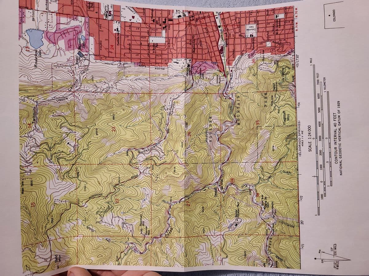
Transcribed Image Text:15TH
:0009
DRIVE
•00
FARMEP
9TH
TH
6400
HIC
TISHIN
SILVER
BROADWA
Gulch
SUnshine
6200-
Cem
Columbia
Gulch
1/2-
BM 5500
15
Wonderland
Lake
QUINGE
70020
WOF
Dake
0099
官
Melody
17
KALMIA
|AVE
County
Øspital
24
PS I
6338
18809
FOREST
SI
AVE
54850 Foorman
E DEE
Poorman
6200-
au
Washingt
BM
Hosp
0009
ALPINE
AVE
69
00+9
Hospital t
9XES
Mapletor
Sunshine
6524
PEARL
LDER
0079
5800
0009-
Ofodel
NOANA
Historical
Markero
Central Park
Highland Sch
ARAPAHOE
Park
186-
MARLNE
ST.
ANDERSON
Filtration Plant
UNIKERSITY
NIVIND
6670
0009
LAS
COLLEGE
PloC Area
Rchic Areal
opt
0009
5825-
Beach
169
PicateArea
06578
AV
AURORA
Mt 8t Gertrude
Academy
Wello
Flagstaff
Mtn
CASCAD
BASELINE
0099
0079
475 17'30"
R. 71 W. R.70 W.
474
|472
(BLDORAD O SPRINGS)
4963 IV NE
471
SCALE 1:24 O00
1 MILE
7000 FEET
0000
0009
NW
000
000
000
000
000
1 KILOMETER
.5
13°
0 12
231 MILS
COLORADO
CONTOUR INTERVAL 40 FEET
STIWS
NATIONAL GEODETIC VERTICAL DATUM OF 1929
Expert Solution
This question has been solved!
Explore an expertly crafted, step-by-step solution for a thorough understanding of key concepts.

This is a popular solution!

Trending now
This is a popular solution!

Step by step
Solved in 3 steps with 2 images

Recommended textbooks for you
Applications and Investigations in Earth Science …
Earth Science
ISBN:
9780134746241
Author:
Edward J. Tarbuck, Frederick K. Lutgens, Dennis G. Tasa
Publisher:
PEARSON

Exercises for Weather & Climate (9th Edition)
Earth Science
ISBN:
9780134041360
Author:
Greg Carbone
Publisher:
PEARSON

Environmental Science
Earth Science
ISBN:
9781260153125
Author:
William P Cunningham Prof., Mary Ann Cunningham Professor
Publisher:
McGraw-Hill Education
Applications and Investigations in Earth Science …
Earth Science
ISBN:
9780134746241
Author:
Edward J. Tarbuck, Frederick K. Lutgens, Dennis G. Tasa
Publisher:
PEARSON
Exercises for Weather & Climate (9th Edition)
Earth Science
ISBN:
9780134041360
Author:
Greg Carbone
Publisher:
PEARSON
Environmental Science
Earth Science
ISBN:
9781260153125
Author:
William P Cunningham Prof., Mary Ann Cunningham Professor
Publisher:
McGraw-Hill Education

Earth Science (15th Edition)
Earth Science
ISBN:
9780134543536
Author:
Edward J. Tarbuck, Frederick K. Lutgens, Dennis G. Tasa
Publisher:
PEARSON

Environmental Science (MindTap Course List)
Earth Science
ISBN:
9781337569613
Author:
G. Tyler Miller, Scott Spoolman
Publisher:
Cengage Learning

Physical Geology
Earth Science
ISBN:
9781259916823
Author:
Plummer, Charles C., CARLSON, Diane H., Hammersley, Lisa
Publisher:
Mcgraw-hill Education,