What average speed, in centimeters/year has the Pacific plate been moving for the past 5 million years? (Hint: Speed = distance/time. Measure distance using the scratch-paper method.) Show your calculations.
What average speed, in centimeters/year has the Pacific plate been moving for the past 5 million years? (Hint: Speed = distance/time. Measure distance using the scratch-paper method.) Show your calculations.

Applications and Investigations in Earth Science (9th Edition)
9th Edition
ISBN:9780134746241
Author:Edward J. Tarbuck, Frederick K. Lutgens, Dennis G. Tasa
Publisher:Edward J. Tarbuck, Frederick K. Lutgens, Dennis G. Tasa
Chapter1: The Study Of Minerals
Section: Chapter Questions
Problem 1LR

Related questions
Question
What average speed, in centimeters/year has the Pacific plate been moving for the past 5 million years? (Hint: Speed = distance/time. Measure distance using the scratch-paper method.) Show your calculations.
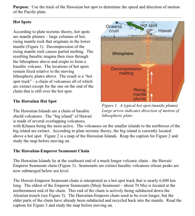
Transcribed Image Text:Purpose: Use the track of the Hawaiian hot spot to determine the speed and direction of motion
of the Pacific plate.
Hot Spots
Họt spot
Oceanic
crust
Hawaii
According to plate tectonic theory, hot spots
are mantle plumes – large columns of hot,
rising mantle rock that originate in the lower
mantle (Figure 1). Decompression of the
rising mantle rock causes partial melting. The
resulting basaltic magma then rises through
the lithosphere above and erupts to form a
basaltic volcano. The locations of hot spots
remain fixed relative to the moving
lithospheric plates above. The result is a "hot
spot track" - a chain of volcanoes all of which
are extinct except for the one on the end of the
chain that is still over the hot spot.
lithosphere
Decompression
melting
Rising
mantle
plume
The Hawaiian Hot Spot
Figure 1. A typical hot spot (mantle plume).
Large arrow indicates direction of motion of
lithospheric plate.
The Hawaiian Islands are a chain of basaltic
shield volcanoes. The “big island" of Hawaii
is made of several overlapping volcanoes,
with Kilauea being the most active. The volcanoes on the smaller islands to the northwest of the
big island are extinct. According to plate tectonic theory, the big island is currently located
above a hot spot. Figure 2 is a map of the Hawaiian Islands. Reap the caption for Figure 2 and
study the map before moving on.
The Hawaiian-Emperor Seamount Chain
The Hawaiian Islands lie at the southeast end of a much longer volcanic chain – the Hawaii-
Emperor Seamount chain (Figure 3). Seamounts are extinct basaltic volcanoes whose peaks are
now submerged below sea level.
The Hawaii-Emperor Seamount chain is interpreted as a hot spot track that is nearly 6,000 km
long. The oldest of the Emperor Seamounts (Meiji Seamount – about 70 Ma) is located at the
northernmost end of the chain. This end of the chain is actively being subducted down the
Aleutian trench (see Figure 3). The Hawaiian-Emperor chain used to be even longer, but the
older parts of the chain have already been subducted and recycled back into the mantle. Read the
caption for Figure 3 and study the map before moving on.
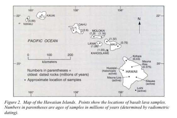
Transcribed Image Text:160
158
156
-22°
KAUAI
22
V4.89)
NIIHAU
OAHU
V3.7)
(2.6) MOLOKAI
(1.9) (1.76)
PACIFIC OCEAN
1.32)
10.75)
LANAI
(1.28)
(1.03)
KAHOOLAWE
MAUI
100
200
Kohala
(0.43)
Mauna
Kea
kilometers
20
20
(0.375)
Hualalai-
(historically
active)
Numbers in parentheses =
oldest dated rocks (millions of years)
Approximate location of samples
HAWAII
Mauna Loa-
(active)
Kilauea
(active)
Loihi
* (active)
160
158
156
Figure 2. Map of the Hawaiian Islands. Points show the locations of basalt lava samples.
Numbers in parentheses are ages of samples in millions of years (determined by radiometric
dating).
Expert Solution
This question has been solved!
Explore an expertly crafted, step-by-step solution for a thorough understanding of key concepts.

This is a popular solution!

Trending now
This is a popular solution!

Step by step
Solved in 2 steps

Recommended textbooks for you
Applications and Investigations in Earth Science …
Earth Science
ISBN:
9780134746241
Author:
Edward J. Tarbuck, Frederick K. Lutgens, Dennis G. Tasa
Publisher:
PEARSON

Exercises for Weather & Climate (9th Edition)
Earth Science
ISBN:
9780134041360
Author:
Greg Carbone
Publisher:
PEARSON

Environmental Science
Earth Science
ISBN:
9781260153125
Author:
William P Cunningham Prof., Mary Ann Cunningham Professor
Publisher:
McGraw-Hill Education
Applications and Investigations in Earth Science …
Earth Science
ISBN:
9780134746241
Author:
Edward J. Tarbuck, Frederick K. Lutgens, Dennis G. Tasa
Publisher:
PEARSON
Exercises for Weather & Climate (9th Edition)
Earth Science
ISBN:
9780134041360
Author:
Greg Carbone
Publisher:
PEARSON
Environmental Science
Earth Science
ISBN:
9781260153125
Author:
William P Cunningham Prof., Mary Ann Cunningham Professor
Publisher:
McGraw-Hill Education

Earth Science (15th Edition)
Earth Science
ISBN:
9780134543536
Author:
Edward J. Tarbuck, Frederick K. Lutgens, Dennis G. Tasa
Publisher:
PEARSON

Environmental Science (MindTap Course List)
Earth Science
ISBN:
9781337569613
Author:
G. Tyler Miller, Scott Spoolman
Publisher:
Cengage Learning

Physical Geology
Earth Science
ISBN:
9781259916823
Author:
Plummer, Charles C., CARLSON, Diane H., Hammersley, Lisa
Publisher:
Mcgraw-hill Education,