A theodolite is used in locating points from a station the elevation of which is 243.39m. The instrument constants are K=100 and C=0. The height of the instrument above the station is 1.37m. Compute the horizontal distances and the elevations. *Note: Zenith Angle is the angle from the vertical line (from the point above the observer). Object Stadia interval, m Rod Reading, m Zenith Angle 114 0.994 1.10 80°31' 115 1.400 1.77 84°10' 116 0.664 1.43 95°24' 117 1.520 1.31 94°35' 118 2.481 1.95 96°30' Answers Object Horizontal Distance to object (in meters) 114 115 116 117 118 Elevation (in meters)
A theodolite is used in locating points from a station the elevation of which is 243.39m. The instrument constants are K=100 and C=0. The height of the instrument above the station is 1.37m. Compute the horizontal distances and the elevations. *Note: Zenith Angle is the angle from the vertical line (from the point above the observer). Object Stadia interval, m Rod Reading, m Zenith Angle 114 0.994 1.10 80°31' 115 1.400 1.77 84°10' 116 0.664 1.43 95°24' 117 1.520 1.31 94°35' 118 2.481 1.95 96°30' Answers Object Horizontal Distance to object (in meters) 114 115 116 117 118 Elevation (in meters)

Traffic and Highway Engineering
5th Edition
ISBN:9781305156241
Author:Garber, Nicholas J.
Publisher:Garber, Nicholas J.
Chapter14: Highway Surveys And Location
Section: Chapter Questions
Problem 12P

Related questions

Question
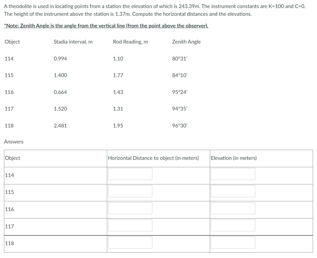
Transcribed Image Text:A theodolite is used in locating points from a station the elevation of which is 243.39m. The instrument constants are K=100 and C=0.
The height of the instrument above the station is 1.37m. Compute the horizontal distances and the elevations.
*Note: Zenith Angle is the angle from the vertical line (from the point above the observer).
Object
Stadia interval, m
Rod Reading, m
Zenith Angle
114
0.994
1.10
80°31'
115
1.400
1.77
84°10'
116
0.664
1.43
95°24'
117
1.520
1.31
94°35'
118
2.481
1.95
96°30'
Answers
Object
Horizontal Distance to object (in meters)
114
115
116
117
118
Elevation (in meters)
Expert Solution
This question has been solved!
Explore an expertly crafted, step-by-step solution for a thorough understanding of key concepts.

This is a popular solution!

Trending now
This is a popular solution!

Step by step
Solved in 3 steps with 5 images

Knowledge Booster


Learn more about
Need a deep-dive on the concept behind this application? Look no further. Learn more about this topic, civil-engineering and related others by exploring similar questions and additional content below.Recommended textbooks for you
Traffic and Highway Engineering
Civil Engineering
ISBN:
9781305156241
Author:
Garber, Nicholas J.
Publisher:
Cengage Learning
Traffic and Highway Engineering
Civil Engineering
ISBN:
9781305156241
Author:
Garber, Nicholas J.
Publisher:
Cengage Learning