. DATA AND RESULTS 1. OBSERVED DATA OBSERVED DISTANCE OBSERVED BEARING LATITUDE DEPARTURE LINE (m) (** ") (m) (m) AB 229.70 N 82° 12' E + 31.17 + 227.57 BC S 48° 12' E + 97.32 130.55 - 87.02 CD S 48° 20' W - 120.61 161.46 - 107.34 EF 180.49 S 87° 43' W - 7.19 - 180.35 EA 171.83 N 07° 59' w + 170.16 - 23.86 D=874.03 0.22 0.07 2. ADJUSTED DATA by COMPASS RULE ADJUSTED ADJUSTED ADJUSTED LINE LATITUDE DE PARTURE DISTANCE (m) BEARING (*") (m) (m) АВ BC CD EF EA G = Cd =
. DATA AND RESULTS 1. OBSERVED DATA OBSERVED DISTANCE OBSERVED BEARING LATITUDE DEPARTURE LINE (m) (** ") (m) (m) AB 229.70 N 82° 12' E + 31.17 + 227.57 BC S 48° 12' E + 97.32 130.55 - 87.02 CD S 48° 20' W - 120.61 161.46 - 107.34 EF 180.49 S 87° 43' W - 7.19 - 180.35 EA 171.83 N 07° 59' w + 170.16 - 23.86 D=874.03 0.22 0.07 2. ADJUSTED DATA by COMPASS RULE ADJUSTED ADJUSTED ADJUSTED LINE LATITUDE DE PARTURE DISTANCE (m) BEARING (*") (m) (m) АВ BC CD EF EA G = Cd =

Chapter2: Loads On Structures
Section: Chapter Questions
Problem 1P

Related questions

Question
CLOSED – COMPASS TRAVERSE
The Given Data is at 2nd photo
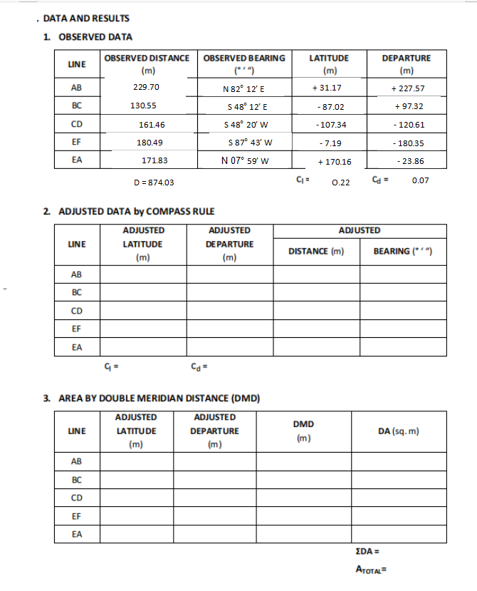
Transcribed Image Text:DATA AND RESULTS
1. OBSERVED DATA
OBSERVED DISTANCE OBSERVED BEARING
LATITUDE
DEPARTURE
LINE
(m)
(*'")
N82° 12' E
S 48° 12' E
(m)
(m)
AB
229.70
+ 31.17
+ 227.57
BC
130.55
- 87.02
+ 97.32
CD
161.46
S 48° 20' W
- 107.34
- 120.61
EF
S 87° 43' W
180.49
- 7.19
- 180.35
EA
171.83
N 07° 59' w
+ 170.16
- 23.86
D= 874.03
Ca =
0.07
0.22
2. ADJUSTED DATA by COMPASS RULE
ADJUSTED
ADJUSTED
ADJUSTED
LINE
LATITUDE
DE PARTURE
DISTANCE (m)
BEARING (*")
(m)
(m)
АВ
BC
CD
EF
EA
3. AREA BY DOUBLE MERIDIAN DISTANCE (DMD)
ADJUSTED
ADJUSTED
DMD
LINE
LATITUDE
DEPARTURE
DA (sq. m)
(m)
(m)
(m)
AB
BC
CD
EF
EA
ΣDA
АтотA
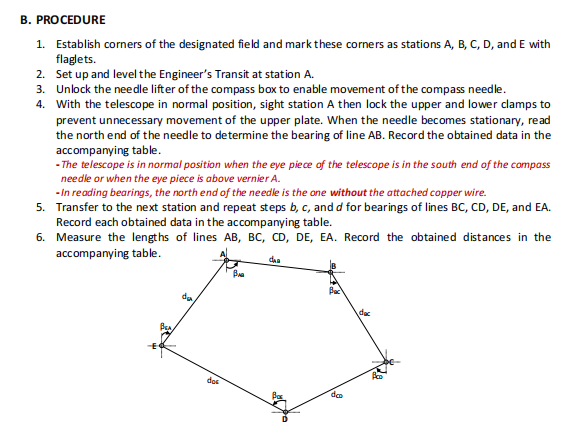
Transcribed Image Text:B. PROCEDURE
1. Establish corners of the designated field and mark these corners as stations A, B, C, D, and E with
flaglets.
2. Set up and level the Engineer's Transit at station A.
3. Unlock the needle lifter of the compass box to enable movement of the compass needle.
4. With the telescope in normal position, sight station A then lock the upper and lower clamps to
prevent unnecessary movement of the upper plate. When the needle becomes stationary, read
the north end of the needle to determine the bearing of line AB. Record the obtained data in the
accompanying table.
- The telescope is in normal position when the eye piece of the telescope is in the south end of the compass
needle or when the eye piece is above vernier A.
- In reading bearings, the north end of the needle is the one without the attached copper wire.
5. Transfer to the next station and repeat steps b, c, and d for bearings of lines BC, CD, DE, and EA.
Record each obtained data in the accompanying table.
6. Measure the lengths of lines AB, BC, CD, DE, EA. Record the obtained distances in the
accompanying table.
daa
de
dac
dns
deo
Expert Solution
This question has been solved!
Explore an expertly crafted, step-by-step solution for a thorough understanding of key concepts.

Step by step
Solved in 5 steps with 1 images

Knowledge Booster


Learn more about
Need a deep-dive on the concept behind this application? Look no further. Learn more about this topic, civil-engineering and related others by exploring similar questions and additional content below.Recommended textbooks for you

Structural Analysis (10th Edition)
Civil Engineering
ISBN:
9780134610672
Author:
Russell C. Hibbeler
Publisher:
PEARSON

Principles of Foundation Engineering (MindTap Cou…
Civil Engineering
ISBN:
9781337705028
Author:
Braja M. Das, Nagaratnam Sivakugan
Publisher:
Cengage Learning
Structural Analysis (10th Edition)
Civil Engineering
ISBN:
9780134610672
Author:
Russell C. Hibbeler
Publisher:
PEARSON
Principles of Foundation Engineering (MindTap Cou…
Civil Engineering
ISBN:
9781337705028
Author:
Braja M. Das, Nagaratnam Sivakugan
Publisher:
Cengage Learning

Fundamentals of Structural Analysis
Civil Engineering
ISBN:
9780073398006
Author:
Kenneth M. Leet Emeritus, Chia-Ming Uang, Joel Lanning
Publisher:
McGraw-Hill Education


Traffic and Highway Engineering
Civil Engineering
ISBN:
9781305156241
Author:
Garber, Nicholas J.
Publisher:
Cengage Learning