DEXOTKYMZAW/ The initial reading of the radar dish detects the drone. The reading of the radar dish indicates an angle of elevation of 60° to the drone. 1. Label the measures of the two acute angles on the diagram above. 2. The straight line beams between the radar dish and the drone registers a distance of 32 km. What is the altitude of where the drone hovers above the location on the ground? km Show how you figured it out.
DEXOTKYMZAW/ The initial reading of the radar dish detects the drone. The reading of the radar dish indicates an angle of elevation of 60° to the drone. 1. Label the measures of the two acute angles on the diagram above. 2. The straight line beams between the radar dish and the drone registers a distance of 32 km. What is the altitude of where the drone hovers above the location on the ground? km Show how you figured it out.
Trigonometry (MindTap Course List)
8th Edition
ISBN:9781305652224
Author:Charles P. McKeague, Mark D. Turner
Publisher:Charles P. McKeague, Mark D. Turner
Chapter7: Triangles
Section7.1: The Law Of Sines
Problem 36PS

Related questions

Concept explainers
Ratios
A ratio is a comparison between two numbers of the same kind. It represents how many times one number contains another. It also represents how small or large one number is compared to the other.
Trigonometric Ratios
Trigonometric ratios give values of trigonometric functions. It always deals with triangles that have one angle measuring 90 degrees. These triangles are right-angled. We take the ratio of sides of these triangles.
Question
Transcribed Image Text:h Me x
E Maria Varg x
Raisin In Th x
A MARS Task X
A Zoom link X
Launch Me x
E/Mjk5MDExOTkyMZAw/a/MZA3MTUYNTKZNTAX/details
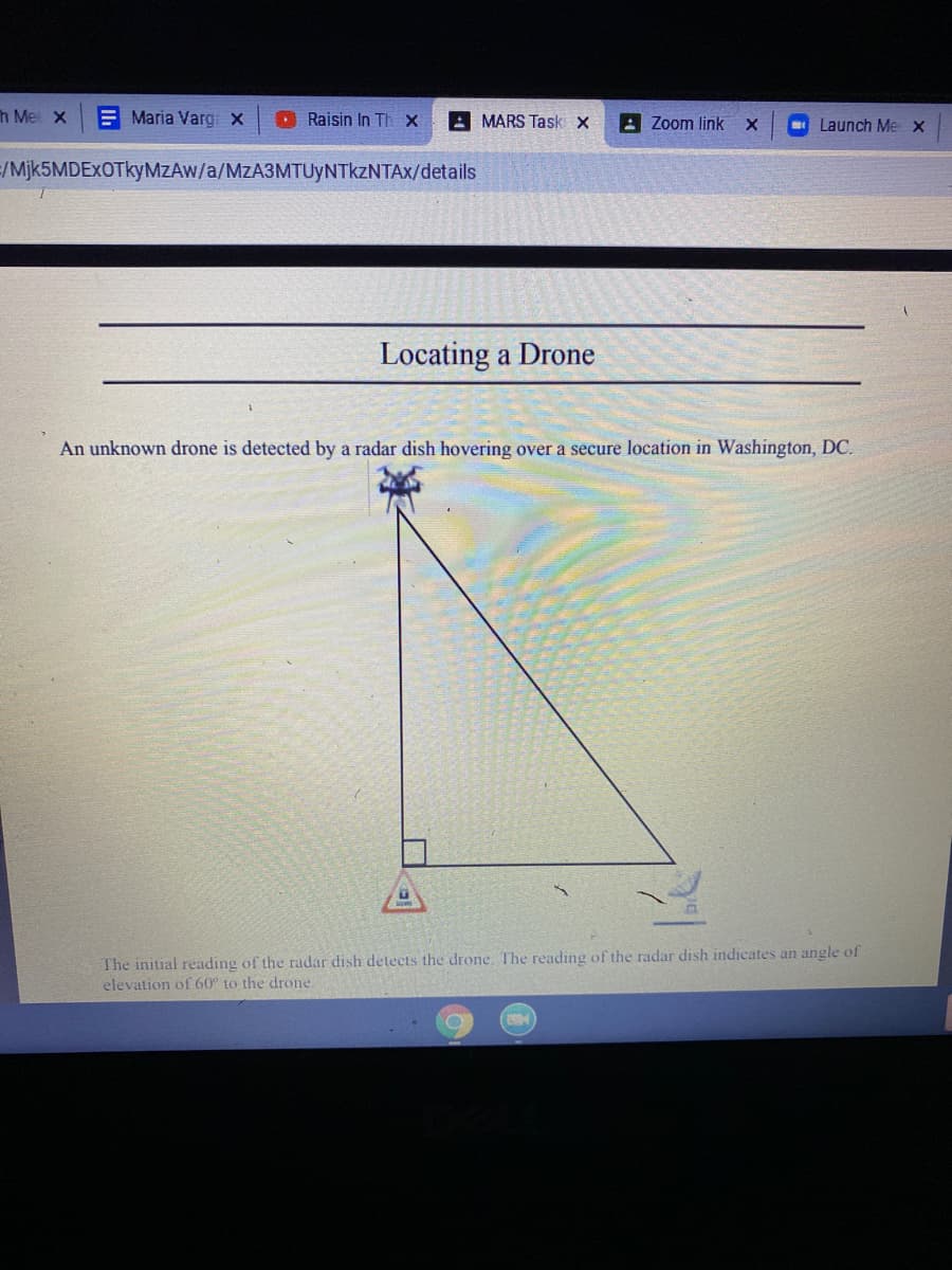
Locating a Drone
An unknown drone is detected by a radar dish hovering over a secure location in Washington, DC.
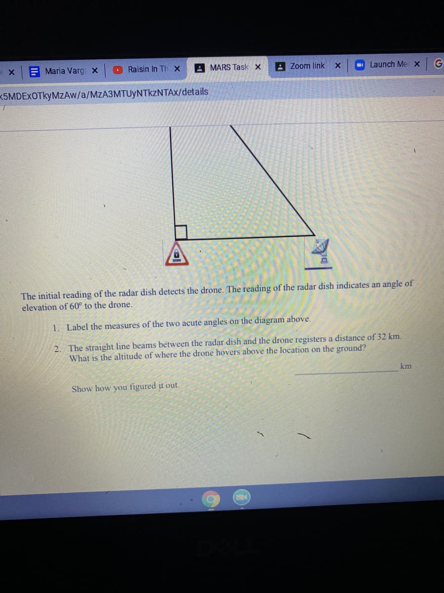
The initial reading of the radar dish detects the drone. The reading of the radar dish indicates an angle of
elevation of 60° to the drone.
Transcribed Image Text:Maria Varg x
D Raisin In Th x
A MARS Task x
A Zoom link
Launch Me x
K5MDEXOTkyMZAw/a/MzA3MTUyNTkzNTAx/details
The initial reading of the radar dish detects the drone. The reading of the radar dish indicates an angle of
elevation of 60° to the drone.
1. Label the measures of the two acute angles on the diagram above.
2. The straight line beams between the radar dish and the drone registers a distance of 32 km.
What is the altitude of where the drone hovers above the location on the ground?
km
Show how you figured it out.
Expert Solution
This question has been solved!
Explore an expertly crafted, step-by-step solution for a thorough understanding of key concepts.

This is a popular solution!

Trending now
This is a popular solution!

Step by step
Solved in 3 steps with 3 images

Knowledge Booster


Learn more about
Need a deep-dive on the concept behind this application? Look no further. Learn more about this topic, advanced-math and related others by exploring similar questions and additional content below.Recommended textbooks for you
Trigonometry (MindTap Course List)
Trigonometry
ISBN:
9781305652224
Author:
Charles P. McKeague, Mark D. Turner
Publisher:
Cengage Learning

Elementary Geometry For College Students, 7e
Geometry
ISBN:
9781337614085
Author:
Alexander, Daniel C.; Koeberlein, Geralyn M.
Publisher:
Cengage,

Holt Mcdougal Larson Pre-algebra: Student Edition…
Algebra
ISBN:
9780547587776
Author:
HOLT MCDOUGAL
Publisher:
HOLT MCDOUGAL
Trigonometry (MindTap Course List)
Trigonometry
ISBN:
9781305652224
Author:
Charles P. McKeague, Mark D. Turner
Publisher:
Cengage Learning
Elementary Geometry For College Students, 7e
Geometry
ISBN:
9781337614085
Author:
Alexander, Daniel C.; Koeberlein, Geralyn M.
Publisher:
Cengage,
Holt Mcdougal Larson Pre-algebra: Student Edition…
Algebra
ISBN:
9780547587776
Author:
HOLT MCDOUGAL
Publisher:
HOLT MCDOUGAL

Algebra & Trigonometry with Analytic Geometry
Algebra
ISBN:
9781133382119
Author:
Swokowski
Publisher:
Cengage
Functions and Change: A Modeling Approach to Coll…
Algebra
ISBN:
9781337111348
Author:
Bruce Crauder, Benny Evans, Alan Noell
Publisher:
Cengage Learning

Mathematics For Machine Technology
Advanced Math
ISBN:
9781337798310
Author:
Peterson, John.
Publisher:
Cengage Learning,