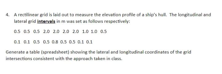
4. A rectilinear grid is laid out to measure the elevation profile of a ship's hull. The longitudinal and lateral grid intervals in m was set as follows respectively: 0.5 0.5 0.5 2.0 2.0 2.0 2.0 1.0 1.0 0.5 0.1 0.1 0.5 0.5 0.8 0.5 0.5 0.1 0.1 Generate a table (spreadsheet) showing the lateral and longitudinal coordinates of the grid intersections consistent with the approach taken in class.
4. A rectilinear grid is laid out to measure the elevation profile of a ship's hull. The longitudinal and lateral grid intervals in m was set as follows respectively: 0.5 0.5 0.5 2.0 2.0 2.0 2.0 1.0 1.0 0.5 0.1 0.1 0.5 0.5 0.8 0.5 0.5 0.1 0.1 Generate a table (spreadsheet) showing the lateral and longitudinal coordinates of the grid intersections consistent with the approach taken in class.
Mathematics For Machine Technology
8th Edition
ISBN:9781337798310
Author:Peterson, John.
Publisher:Peterson, John.
Chapter38: Achievement Review—section Three
Section: Chapter Questions
Problem 10AR
Related questions
Question
7

Transcribed Image Text:4. A rectilinear grid is laid out to measure the elevation profile of a ship's hull. The longitudinal and
lateral grid intervals in m was set as follows respectively:
0.5 0.5 0.5 2.0 2.0 2.0 2.0 1.0 1.0 0.5
0.1 0.1 0.5 0.5 0.8 0.5 0.5 0.1 0.1
Generate a table (spreadsheet) showing the lateral and longitudinal coordinates of the grid
intersections consistent with the approach taken in class.
Expert Solution
This question has been solved!
Explore an expertly crafted, step-by-step solution for a thorough understanding of key concepts.
Step by step
Solved in 2 steps with 4 images

Recommended textbooks for you

Mathematics For Machine Technology
Advanced Math
ISBN:
9781337798310
Author:
Peterson, John.
Publisher:
Cengage Learning,

Elementary Geometry For College Students, 7e
Geometry
ISBN:
9781337614085
Author:
Alexander, Daniel C.; Koeberlein, Geralyn M.
Publisher:
Cengage,


Mathematics For Machine Technology
Advanced Math
ISBN:
9781337798310
Author:
Peterson, John.
Publisher:
Cengage Learning,

Elementary Geometry For College Students, 7e
Geometry
ISBN:
9781337614085
Author:
Alexander, Daniel C.; Koeberlein, Geralyn M.
Publisher:
Cengage,
