Concept explainers
Types of kinematic surveys.
Answer to Problem 15.1P
Types of kinematic
1. Real time kinematic survey
2. Post process kinematic survey
Explanation of Solution
Surveying plays is an important role in all engineering projects. By measuring the horizontal and vertical direction and angle, it is an art and science to find the relative position of various valuable points or stations on the earth's surface. We prepare plans, maps, or layout by these points.
The most effective and fastest survey technique is Kinematic surveying. The relative positioning technique is used for the observation of the carrier phase shift. The cinematic survey can provide the coordinate of the points with the fastest values while the receiver is motionless or in motion.
The two types of kinematic survey are:
1. Real time kinematic survey
The Real time kinematic survey (RTK) is also referred to as the relative positioning technique that measures the position in real time using two global navigation satellite systems (GNSS). One is placed at a static point with established coordinates and is known as the base station. It carries a large frequency radio to the second unit (known as the rover) with its raw observation and the rover carries both observations to determine a position relative to the base location in real time.
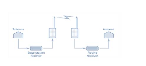
RTK surveying requires positive communication between base and rover units and works best with short baselines as the accuracy of measurements or analysis of RTK decreases as the length of the baseline increases.
2. Post process kinematic survey
A post process kinematic survey requires a base receiver that collects data at the same time rate as the rover. In the Kinematic survey of post processes, the identified coordinates should be stored in the survey controller and the observations of the raw global navigation satellite system (GNSS) are saved in the recipient until the fieldwork is completed. The data are then processed by the same software and processing techniques used in static surveys in the office.
Want to see more full solutions like this?
Chapter 15 Solutions
Elementary Surveying: An Introduction to Geomatics (15th Edition)


 Structural Analysis (10th Edition)Civil EngineeringISBN:9780134610672Author:Russell C. HibbelerPublisher:PEARSON
 Principles of Foundation Engineering (MindTap Cou...Civil EngineeringISBN:9781337705028Author:Braja M. Das, Nagaratnam SivakuganPublisher:Cengage Learning
 Fundamentals of Structural AnalysisCivil EngineeringISBN:9780073398006Author:Kenneth M. Leet Emeritus, Chia-Ming Uang, Joel LanningPublisher:McGraw-Hill Education
 Traffic and Highway EngineeringCivil EngineeringISBN:9781305156241Author:Garber, Nicholas J.Publisher:Cengage Learning