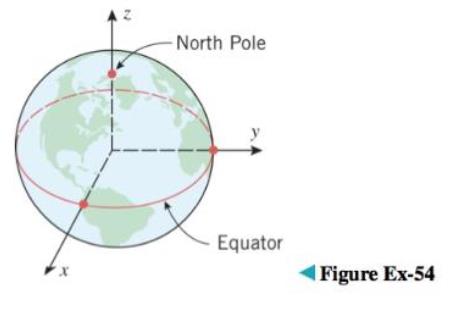
The Earth’s rotation causes a flattening at the poles, so its shape is often modeled as an oblate spheroid rather than a sphere (see Exercise 53 for terminology). One of the models used by global positioning satellites is the World Geodetic System of 1984 (WGS-84), which treats the Earth as an oblate spheroid whose equatorial radius is 6378.1370 km and whose polar radius (the distance from the Earth’s center to the poles) is 6356.5231 km. Use the WGS-84 model to find an equation for the surface of the Earth relative to the coordinate system shown in the ac-companying figure.
The Earth’s rotation causes a flattening at the poles, so its shape is often modeled as an oblate spheroid rather than a sphere (see Exercise 53 for terminology). One of the models used by global positioning satellites is the World Geodetic System of 1984 (WGS-84), which treats the Earth as an oblate spheroid whose equatorial radius is 6378.1370 km and whose polar radius (the distance from the Earth’s center to the poles) is 6356.5231 km. Use the WGS-84 model to find an equation for the surface of the Earth relative to the coordinate system shown in the ac-companying figure.
The Earth’s rotation causes a flattening at the poles, so its shape is often modeled as an oblate spheroid rather than a sphere (see Exercise 53 for terminology). One of the models used by global positioning satellites is the World Geodetic System of 1984 (WGS-84), which treats the Earth as an oblate spheroid whose equatorial radius is 6378.1370 km and whose polar radius (the distance from the Earth’s center to the poles) is 6356.5231 km. Use the WGS-84 model to find an equation for the surface of the Earth relative to the coordinate system shown in the ac-companying figure.
System that uses coordinates to uniquely determine the position of points. The most common coordinate system is the Cartesian system, where points are given by distance along a horizontal x-axis and vertical y-axis from the origin. A polar coordinate system locates a point by its direction relative to a reference direction and its distance from a given point. In three dimensions, it leads to cylindrical and spherical coordinates.
In 1992,a NASA team began a project called Spaceguard Survey, calling for an international watch for comets that might collide with Earth. Why is it more difficult to detect a possible “doomsday comet” with a hyperbolic orbit than one with an elliptical orbit?
What type of three-dimensional object forms when a semicircle is rotated around the x-axis?
Create one model or figure for a Klein-Beltrami model of hyperbolic geometry.
Chapter 11 Solutions
Calculus Early Transcendentals, Binder Ready Version
Precalculus: Mathematics for Calculus (Standalone Book)
Knowledge Booster
Learn more about
Need a deep-dive on the concept behind this application? Look no further. Learn more about this topic, calculus and related others by exploring similar questions and additional content below.


 Elementary Geometry For College Students, 7eGeometryISBN:9781337614085Author:Alexander, Daniel C.; Koeberlein, Geralyn M.Publisher:Cengage,
 Linear Algebra: A Modern IntroductionAlgebraISBN:9781285463247Author:David PoolePublisher:Cengage Learning
 Algebra & Trigonometry with Analytic GeometryAlgebraISBN:9781133382119Author:SwokowskiPublisher:Cengage
 Holt Mcdougal Larson Pre-algebra: Student Edition...AlgebraISBN:9780547587776Author:HOLT MCDOUGALPublisher:HOLT MCDOUGAL