
Concept explainers
The scale of the first vertical aerial photograph and the flying height of both the photographs.
Answer to Problem 10P
Explanation of Solution
Given information:
Calculation:
Take two control points on a vertical aerial photograph:
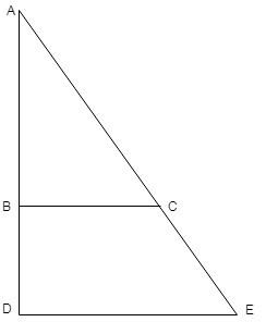
Let the length of DE
We have been given the value of BC
For scale two the value of X is found as follows:
Substituting the values, we get
Now, the value of BC
We have the following formula, for scale first:
Substituting the values, we get
Implying that the scale of the first vertical photograph is
Now, the flying height
Where,
The flying height of the first photograph is,
Now, the flying height
Where,
The flying height of the first photograph is,
Conclusion:
Therefore,the scale of the first vertical photograph is
Want to see more full solutions like this?
Chapter 14 Solutions
Traffic and Highway Engineering


- A camera was equipped with a 152mm (6”) focal-length lens is used to take a verticalphotograph from a flying height of 2780m above mean sea level. If the terrain is flat and locatedat an elevation of 500m.a.) What is the scale of the photograph?b.) What would be the scale at mean sea level?arrow_forwardA vertical photograph was taken, with a camera having a 152.9-mm focal length, from a flying height 2160 m above sea level. What is the scale of the photo at an elevation of 385 m above sea level? What is the datum scale?arrow_forwardA camera with a focal length of 20 cm fitted in an aircraft is used for taking vertical aerial photographs of a terrain. The average elevation of the terrain is 1200 m above mean sea level (MSL). What is the height above MSL at which an aircraft must fly in order to get the aerial photographs at a scale of 1:8000?arrow_forward
- A drone is equipped with a small format digital camera that has an APS-H sensor (see image) and a focal length of f = 13 mm. The flying height H’ over an approximately flat terrain is 1500 m. Two stereopairs are to be captured with 65% overlap at the same flying height. See example image below. What is the area of overlap on the ground in square meters?arrow_forwardA 98% efficient ESP is to treat a gas stream flowing at 5000 m3/ min. If the effective drift velocity is 6.0 cm/s, calculate the plate area {required and actual) in m2.arrow_forwardA fishing vessel with a green light on its deck, 8.5m above the water, disappears from the sight of a man on shore whose eye level measures 1.20 m above the water. Determine the distance between the vessel and the man.arrow_forward
- A pole cast a shadow 15 m long when the angle of elevation of the sun is 63°. If the pole leans 15° from the vertical towards the sun, determine the length of the pole.arrow_forwardAn object is launched at a velocity of 100 m/s in a direction making an angle of 30° upward with the horizontal. What is the horizontal range of the object? *arrow_forwardWhen using an optical instrument, such as an Automatic Level, you should focus on: Question 11Select one: A. The image B. The cross hairs Incorrect C. The mirrors D. Both a and barrow_forward
- An aerial photograph of a terrain is taken at a scale of 1:7500, For 4000 m altitude of the flight above mean sea level and 30 cm focal length of the camera, the expected average elevation of the terrain will be____meter.arrow_forwardWhich car car showed the greatest acceleration going to the right (horizontally)?arrow_forward
 Traffic and Highway EngineeringCivil EngineeringISBN:9781305156241Author:Garber, Nicholas J.Publisher:Cengage Learning