Sketch, label, and discuss the hydrologic cycle.
Earth's water is constantly moving between Earth's surface and atmosphere. The hydrologic cycle describes the continuous movement of water from the oceans to the atmosphere, from the atmosphere to the land, and from the land back to the sea Over most of Earth, the Quantity of precipitation that falls on the land must eventually be accounted for by the sum total of evaporation, transpiration (the release water vapor by vegetation), runoff, and infiltration
A portion of the precipitation that falls on land will soak into the ground through a process called infiltration. If the rate of rainfall exceeds the ability of the surface to absorb it, the additional water flows over the surface and becomes runoff. Runoff initially flows in broad sheets that form tiny channels called rills The rills merge to form gullies, which eventually join to create streams erosion by both groundwater and running water wears down the land and shapes Earth's surface
Figure 8.1 illustrates Earth's water balance, a quantitative view of the hydrologic cycle The figure Implies a globally uniform exchange of water between Earth's atmosphere and surface, but factors such as climate, steepness of slope, surface materials, vegetation, and degree of urbanization produce local variations
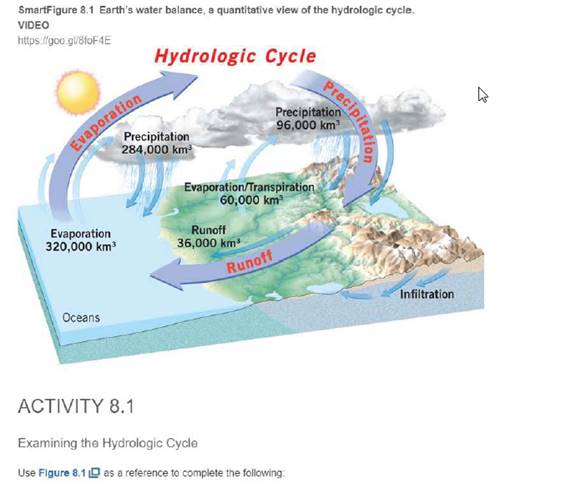
Much of the water that falls on land does not Immediately return to the ocean via runoff Instead, It is temporarily stored in reservoirs such as lakes in some mountainous and polar regions, what features serve as reservoirs to temporanly store water

Learn your wayIncludes step-by-step video

Chapter 4 Solutions
Applications and Investigations in Earth Science (8th Edition)
Additional Science Textbook Solutions
Exercises for Weather & Climate (9th Edition)
Organic Chemistry (8th Edition)
Campbell Biology in Focus (2nd Edition)
Chemistry: Structure and Properties (2nd Edition)
Human Physiology: An Integrated Approach (8th Edition)
Fundamentals of Anatomy & Physiology Plus Mastering A&P with eText - Access Card Package (10th Edition) (New A&P Titles by Ric Martini and Judi Nath)

 Applications and Investigations in Earth Science ...Earth ScienceISBN:9780134746241Author:Edward J. Tarbuck, Frederick K. Lutgens, Dennis G. TasaPublisher:PEARSON
 Exercises for Weather & Climate (9th Edition)Earth ScienceISBN:9780134041360Author:Greg CarbonePublisher:PEARSON
 Environmental ScienceEarth ScienceISBN:9781260153125Author:William P Cunningham Prof., Mary Ann Cunningham ProfessorPublisher:McGraw-Hill Education
 Earth Science (15th Edition)Earth ScienceISBN:9780134543536Author:Edward J. Tarbuck, Frederick K. Lutgens, Dennis G. TasaPublisher:PEARSON
 Environmental Science (MindTap Course List)Earth ScienceISBN:9781337569613Author:G. Tyler Miller, Scott SpoolmanPublisher:Cengage Learning
 Physical GeologyEarth ScienceISBN:9781259916823Author:Plummer, Charles C., CARLSON, Diane H., Hammersley, LisaPublisher:Mcgraw-hill Education,