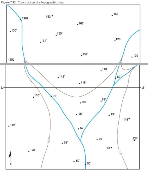
Use the elevations in Figure 7.12 as a guide for drawing contour lines. The 100-foot contour line is provided for reference. Using a 20-foot contour interval, use a pencil to draw a contour line for each 20-foot change in elevation below and above 100 feet (eg. 60 feet, 80 feet, 120 feet) You will have to estimate the elevations between the points. Label each contour line with its elevation

Learn your wayIncludes step-by-step video

Chapter 7 Solutions
Applications and Investigations in Earth Science Plus Mastering Geology with Pearson eText -- Access Card Package (9th Edition) (What's New in Geosciences)
Additional Science Textbook Solutions
Exercises for Weather & Climate (9th Edition)
Applications and Investigations in Earth Science (8th Edition)
College Physics (10th Edition)
Brock Biology of Microorganisms (14th Edition)
Becker's World of the Cell (9th Edition)

 Applications and Investigations in Earth Science ...Earth ScienceISBN:9780134746241Author:Edward J. Tarbuck, Frederick K. Lutgens, Dennis G. TasaPublisher:PEARSON
 Exercises for Weather & Climate (9th Edition)Earth ScienceISBN:9780134041360Author:Greg CarbonePublisher:PEARSON
 Environmental ScienceEarth ScienceISBN:9781260153125Author:William P Cunningham Prof., Mary Ann Cunningham ProfessorPublisher:McGraw-Hill Education
 Earth Science (15th Edition)Earth ScienceISBN:9780134543536Author:Edward J. Tarbuck, Frederick K. Lutgens, Dennis G. TasaPublisher:PEARSON
 Environmental Science (MindTap Course List)Earth ScienceISBN:9781337569613Author:G. Tyler Miller, Scott SpoolmanPublisher:Cengage Learning
 Physical GeologyEarth ScienceISBN:9781259916823Author:Plummer, Charles C., CARLSON, Diane H., Hammersley, LisaPublisher:Mcgraw-hill Education,