
APPLICATIONS+INVESTIGATIONS IN EARTH
18th Edition
ISBN: 9781533902405
Author: Tarbuck
Publisher: Hayden-McNeil Publishing
expand_more
expand_more
format_list_bulleted
Textbook Question
Chapter 7.9, Problem 9A
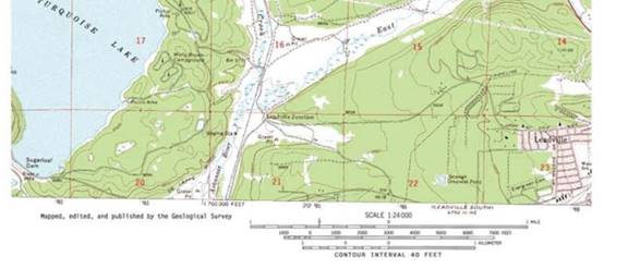
Describe the change in elevation you would encounter as you walked from the boat ramp (Point A) on the northeast shore of Turquoise Lake, directly northward along the dashed line to Point B (Use terms such as steep, gradual, moderate, uphill, downhill, and relatively flat)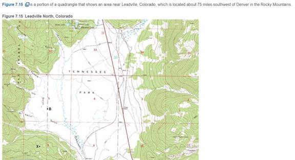
Expert Solution & Answer

Learn your wayIncludes step-by-step video

schedule04:18
Students have asked these similar questions
Please read the first picutre, and answer on the second picture. thanks for your time
In the image you can look at the question . Is asking me to choose the correct answer below and fill in the answer box to complete your choice . How can I solve this type of question ?
Please read the first picture and please answer on the second. Thank you for your time
Chapter 7 Solutions
APPLICATIONS+INVESTIGATIONS IN EARTH
Ch. 7.1 - Obtain a stereoscope from your instructor, unfold...Ch. 7.1 - Prob. 2ACh. 7.1 - Prob. 3ACh. 7.1 - Prob. 4ACh. 7.2 - Prob. 1ACh. 7.2 - Prob. 2ACh. 7.3 - Prob. 1ACh. 7.3 - Prob. 3ACh. 7.3 - Prob. 6ACh. 7.4 - Depending on the map scale, 1 inch on a...
Ch. 7.4 - Examine Figure 7.6 and complete the map...Ch. 7.6 - The difference in elevation between adjacent...Ch. 7.6 - What is the difference in elevation between Points...Ch. 7.6 - Notice that every fifth contour line, called an...Ch. 7.6 - Prob. 4ACh. 7.6 - One or more roughly circular closed contours...Ch. 7.6 - Closed contours with hachures short lines that...Ch. 7.6 - When contour lines cross streams or dry stream...Ch. 7.6 - Estimating the elevations of places not located on...Ch. 7.6 - Relief is defined as the difference in elevation...Ch. 7.7 - Use the elevations in Figure 7.12 as a guide for...Ch. 7.7 - Does the land shown on the topographic map you...Ch. 7.7 - Use the profile graph in Figure 7.14 to construct...Ch. 7.8 - Use the profile graph in Figure 7.14 to construct...Ch. 7.9 - What is the contour interval of this map?Ch. 7.9 - What is the difference in elevation from one index...Ch. 7.9 - Prob. 3ACh. 7.9 - Locate the small intermittent stream blue dashed...Ch. 7.9 - What is the approximate elevation of the point...Ch. 7.9 - What is the approximate relief between point X and...Ch. 7.9 - Which of the following phrases best describes the...Ch. 7.9 - The area on both sides of Tennessee Creek in...Ch. 7.9 - Describe the change in elevation you would...Ch. 7.9 - What is the elevation of the town of Leadville,...Ch. 7.9 - Prob. 11ACh. 7 - Determine the contour interval used on this map...Ch. 7 - List the elevations of each index contour on the...Ch. 7 - What are the elevations of the locations...Ch. 7 - What is the elevation of the church? Elevation of...Ch. 7 - Indicate two areas on this map that have steep...Ch. 7 - Describe the relief of Sandy Spit with one of the...Ch. 7 - Mark the top of the hill in the northeast corner...Ch. 7 - Is the top of Picture Ridge, designated Y, at a...Ch. 7 - What is the maximum relief shown on this contour...Ch. 7 - Imagine that you are taking a group of friends...Ch. 7 - Use the satellite images in figure 7.17, which...
Additional Business Textbook Solutions
Find more solutions based on key concepts
In the winter, cold air is brought into homes and heated. How does this change the relative humidity of the air...
Exercises for Weather & Climate (9th Edition)
82. Doubling the frequency of a wave in the range of 25 Hz to 3 kHz represents what change in the maximum allow...
College Physics (10th Edition)
Magnesium crystallizes in the hcp arrangement shown in Figure 12-41. The dimensions of the unit cell are height...
General Chemistry: Principles and Modern Applications (11th Edition)
a. Prepare a molecular orbital energy-level diagram for NO showing clearly how the atomic orbitals interact to ...
Inorganic Chemistry
Biogeochemical cycling involves three primary steps: __________, __________, and ______.
Microbiology with Diseases by Taxonomy (5th Edition)
Gray whales (Eschrichtius robustus) gather each winter near Baja California to give birth. How might such behav...
Campbell Biology (10th Edition)
Knowledge Booster

Similar questions
- Good day , please may you assist with this question , please also look at the second image , the +/- signs need to be shownarrow_forwardi requseted you to solve the question given in the image box....i will be thankful..arrow_forwardUse the following information to answer the questions that follow. A. Calculate the operating income percentage for each of the courses. Comment on how your analysis has changed for each course. B. Perform a vertical analysis for each course. Based on your analysis, what accounts would you want to investigate further? How might management utilize this information? C. Which method of analysis (using a dollar value or percentage) is most relevant and/or useful? Explainarrow_forward
- You have been asked by your manager to review three potential investment opportunities. As part of your investigation, you are asked to provide calculated data for three different methods of comparison. What three methods do you decide to use for your calculations? Explain why you are choosing each of these methods. (Explain your answer in a minimum of 3 complete sentences.)arrow_forwardANSWER THE PROBLEM QUESTION AND BOX THE FINAL ANSWER. WRITE ON A CLEAR PAPER CLEARLY.arrow_forwardWrite your answer on clean paper, show your solution clearly and readable, and then Box your final answer. Take note: Give what is asked and show your answer.arrow_forward
arrow_back_ios
SEE MORE QUESTIONS
arrow_forward_ios
Recommended textbooks for you
 Principles of Accounting Volume 2AccountingISBN:9781947172609Author:OpenStaxPublisher:OpenStax College
 Survey of Accounting (Accounting I)AccountingISBN:9781305961883Author:Carl WarrenPublisher:Cengage Learning
Principles of Accounting Volume 2
Accounting
ISBN:9781947172609
Author:OpenStax
Publisher:OpenStax College
Survey of Accounting (Accounting I)
Accounting
ISBN:9781305961883
Author:Carl Warren
Publisher:Cengage Learning