
Concept explainers
Videos
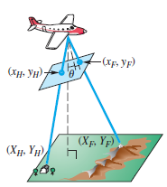
Aerial Photography Aerial photographs can be used to provide coordinates of ordered pairs to determine distances on the ground. Suppose we assign coordinates as shown in the figure. If an object’s photographic coordinates are (x, y), then its ground coordinates (X. Y) in feet can be computed using the following formulas.
Here. f is focal length of the camera in inches, a is altitude in feet of the airplane, and h is elevation in feet of the object. Suppose that a house has photographic coordinates (xH' yH) = (0.9. 3.5) with elevation 150 ft. and a nearby forest fire has photographic coordinates (xF. yF) = (2.1. -2.4) and is at elevation 690 ft. Also suppose the photograph was taken at 7400 ft by a camera with focal length 6 in. and tilt
(a) Use the formulas to find the ground coordinates of the house and the fire to the nearest tenth of a foot.
(b) Use the distance formula
to find the distance on the ground between the house and the fire to the nearest tenth of a foot.
Want to see the full answer?
Check out a sample textbook solution
Chapter 7 Solutions
Trigonometry (11th Edition)


 Algebra & Trigonometry with Analytic GeometryAlgebraISBN:9781133382119Author:SwokowskiPublisher:Cengage
 Trigonometry (MindTap Course List)TrigonometryISBN:9781337278461Author:Ron LarsonPublisher:Cengage Learning
 College Algebra (MindTap Course List)AlgebraISBN:9781305652231Author:R. David Gustafson, Jeff HughesPublisher:Cengage Learning